Rhône AGG Description/DocumentationLast update: April 18, 2001 The document is presented here: a print version is also available via anonymous ftp in gzipped (GNU-zipped) PostScript format: PostScript If you have any problems downloading the file, please contact Aaron Boone (boone@cnrm.meteo.fr). Table of Contents
Rhône Modeling SystemThe Rhône modeling system was developed in recent years by the French research community with the main goal of this project being the development of an atmospheric interface to a distributed hydrological model applied at a regional scale. The system was developed in such a way that it can be transfered to other regions, and it utilizes high spatial resolution European soil and vegetation databases. This system has been created in an attempt to ensure a consistent dialogue between the atmospheric (precipitation, radiative fluxes, state variables) and the hydrological variables (evaporation, soil moisture, runoff, ground water and river flow). Three distinct components comprise this system: a distributed hydrological model, an analysis system to determine the near-surface atmospheric forcing and a soil-vegetation-atmosphere transfer (SVAT) model interface. The atmosphere-soil (near surface hydrology) interface is based on the Interactions between the Soil-Biosphere-Atmosphere (ISBA) SVAT scheme (Noilhan and Planton 1989; Noilhan and Mahfouf 1996) which is used in the operational weather prediction models ARPEGE (Action de Recherche a Petite Et Grande Echelle: Courtier et Geleyn 1988), of the French weather service (Giard and Bazile 2000), the ARPEGE global atmospheric climate model (GCM: Mahfouf et al. 1995), a meso-scale atmospheric research model, and it is coupled to a distributed hydrological model ( Habets et al. 1999a) called MODCOU (Ledoux et al. 1989: Violette et al. 1997). One of the most important functions of this interface is to model the rapid interaction between the atmosphere and the surface through an explicit resolution of the daily cycle, and the slower interaction with the deep soil layers and the hydrological system. The system is run using a spatial resolution ranging from as small as 1 km (the lower limit for the hydrological model) to 8 km (the atmospheric/SVAT grid), and the system can currently be run for as long as 17 years (1981-1998). The large simulation domain and time span are used in order to consider a wide range of hydrological responses and climate conditions (Etchevers et al. 2001). The coupling between the three components of the system is 1-way. The surface runoff and drainage from ISBA are fed into the MODCOU model at a daily time step. MODCOU then is used to calculate the river routing and the evolution of the water table. It is important to note that the other two components of the system have been developed and calibrated independently of ISBA so that, in principle, different SVAT schemes can easily be inserted into the system in the place of ISBA. SVAT Intercomparison and ValidationNumerous field experiments have been done over the years with the objective of improving the understanding of the link between the land-surface and the atmosphere (eg.s HAPEX-MOBILHY: André et al., 1986, FIFE: Sellers et al., 1988, BOREAS: Sellers et al., 1997, Cabauw, Netherlands: Beljaars and Bosveld, 1997). This data has proven to be of particular value in terms of SVAT model evaluation. The Project for the Intercomparison of Land-surface Parameterization Schemes (PILPS: Henderson-Sellers et al., 1993; 1995) has increased the understanding of SVAT models, and it has lead to many improvements in the schemes themselves. In Phase-2 of PILPS, SVAT schemes have been used in so-called ``off-line mode'' (driven using prescribed atmospheric forcing as opposed to being coupled to an atmospheric model), and the resulting simulations have been compared to observed data (including data from some of the aforementioned field experiments). Data representing a local scale or an atmospheric model grid box were used by PILPS phases 2a (Cabauw: Chen et al. 1997) and 2b (HAPEX-MOBILHY: Shao and Henderson-Sellers, 1996) for a single annual cycle, and phase 2d (Schlosser et al., 2000) for a multi-year simulation. The primary results of these studies showed the importance of the model parameterizations of soil moisture, the link between soil water (stress) and transpiration, and cold-season processes, respectively. In PILPS-2c (Wood et al. 1998), multi-year basin-scale SVAT simulations over the southern-Central Plains of the US were evaluated using a river routing model and observed daily river discharge. Sub-grid runoff parameterizations were shown to be of critical importance in terms of correctly simulating river discharge when using daily precipitation data as forcing for the spatial scales considered (1x1 degree grid elements). PILPS-2e (Lettenmaier and Bowling, 2000) is similar to phase 2c, except that the basin is located at a relatively high latitude, and the river-flows are controlled to a large extent by lake and soil freeze-thaw and snow melt. In addition, the spatial resolution of the computational grid is 1/4 x 1/4 degrees. Other ``off-line'' SVAT intercomparison studies have also been done using a PILPS-type approach. The Global Soil Wetness Project (GSWP) (1.0: Dirmeyer et al. 1999) analyzed 2-year global SVAT simulations, with an important objective of establishing a global soil wetness climatology. The Snow Model Intercomparison Project ( SnowMIP: Essery et al. 1999) focuses on the snow simulations by various operational (avalanche prediction), SVAT and detailed internal process snow models at the local scale. Rhône AGGregation experimentThe Rhône AGGregation experiment is an initiative within the GEWEX/GLASS (Global Land-Atmosphere System Study : Polcher et al. 2000)/GSWP (GSWP : Dirmeyer et al. 1999) panel of the WCRP. The Rhône model domain is on the order of the size of a coarse-resolution global atmospheric climate model grid box, but the atmospheric forcing and river gauge network is at a significantly higher resolution. Therefore, the main objective of Rhône-AGG is to examine how the simulations from a wide range of SVAT schemes, which are used in GCMs, atmospheric models or for local scale studies, are impacted by changing the spatial resolution. This objective addresses one of the key questions to come out of the La Jolla IGBP/GEWEX workshop ( Dolman and Dickinson, 1997). The Rhône-AGG experiment is an intermediate step toward GSWP 2. Four years have been selected for the simulations: 1985-1988. They were chosen in order to coincide with the GSWP 1.0 and 1.5 (1987-1988). The ultimate goal of the Rhône-AGG project is similar to PILPS: this project seeks to increase the understanding of SVAT schemes and the reasons for simulation disparity. It most resembles phases 2c and 2e, in that observed river discharge at a basin scale will be used to evaluate the SVAT schemes. This project differs from the aforementioned PILPS projects primarily owing to the much larger spatial resolution (8x8 km), the large within-basin range in vegetation types (rocks/bare soil, agriculture, grassland and both deciduous and pine forests) and climate (Mediterranean, maritime-continental and alpine), the large grid-box average altitude gradient (eg. in PILPS-2e, it ranges from 20-1150 m, in this project it ranges from 7-3011 m), and the primary objective of examining the effect of parameter aggregation. Aspects of the modeled snow cover, such as the spatial coverage, timing of ablation and impact on the river discharge, will be examined, but a more in-depth analysis of the simulated snowpack is beyond the scope of this study (as the detailed evaluation of SVAT simulated snowpack at a local scale using high-quality observational data is the main objective of SnowMIP). The climates used in certain PILPS exercises and for the Rhône domain are shown in Fig. 1.1. The monthly averages of several of the atmospheric forcing components are shown: the incoming solar radiation (Rg), atmospheric longwave radiation (Rat), the near-surface air temperature (Ta), and the precipitation components (rain and snow are represented by the solid and dashed lines, respectively). Note that the Torne (PILPS-2e) and the Rhône are basin-scale averages (right column), and the monthly averages are taken over multi-year periods for Valdai (PILPS-2d: 18 years), Torne (PILPS-2e: 10 years) and the Rhône (4 years). The Rhône valley has the least monthly variability in terms of precipitation for the years examined, and it is one of the wettest of the experiments shown. The basin-scale climate is in sharp contrast to the Torne basin, which is a much colder basin on average. Note that even though the basin is significantly warmer than the Torne, the snow component is still quite important (in the highest mountainous regions over 1400 kg m-2 of snow liquid water equivalent falls on average). The significant within-basin climate contrasts of the Rhône basin are further discussed in Chapter 2. . 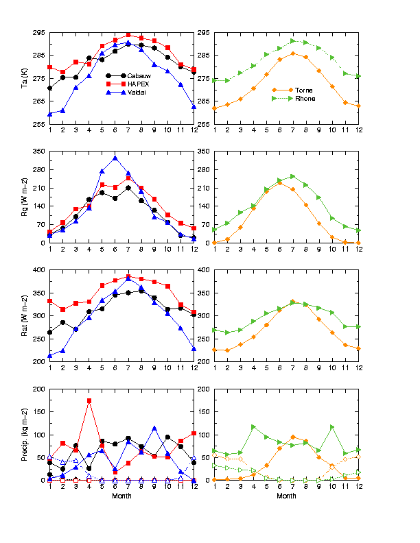 FIG. 1.1 The climates from various PILPS exercises and the Rhône for the experiment described herein. The near-surface air temperature (Ta), incoming solar radiation (Rg), downwelling atmospheric longwave radiation (Rat), and precipitation components (solid line for rain, dashed line for snow) are shown. An effort has been made to design this experiment in a way that is as consistent as possible with the GSWP and the PILPS-2e, model intercomparison project set-ups in order to facilitate participation by various modeling groups. The Assistance for Land-surface Modelling Activities (ALMA) convention for the atmospheric variables and land-surface parameter inputs is used, and a similar degree of freedom, in terms of land-surface parameters, is used as in PILPS-2e, (it is desired that models run in their default configurations as much as possible). Gridded surface parameter datasets have been prepared along with correspondence tables (for those who wish to aggregate their own surface parameters or estimate additional gridded parameters). The number of experiments has been limited to as few as possible while still being able to adequately address the posed science questions. The three baseline experiments are described in Chapter 3. The possibility of doing additional experiments will be discussed at the Rhône-AGG workshop. Scientific ObjectivesThe main scientific questions of the Rhône aggregation experiment (Rhône-AGG) to be addressed are;
ScheduleThe preliminary timeline is shown in Table 1.1. The need for any reruns can be discussed at the workshop. As is standard procedure in PILPS, we will make an effort to contact any groups which have anomalous or questionable results prior to the workshop. TABLE 1.1 Schedule for data distribution, return of results and a workshop.
The Rhône database is described in Chapter 2, the experimental set-up is outlined in Chapter 3, and the input parameters are described in Chapter 4. The requested output variables are listed in Chapter 5. |