Rhône AGG Description/Documentation
The experimental setup is described in this section. Experiment DescriptionTime frameThe model forcing consists of 4 years: starting August 1, 1985, and ending July 31, 1989. The first year (ending July 31, 1986) is to be treated as a spin-up year, so we ask that the participants provide results for the final three years (August 1, 1986-July 31 1989). The simulations begin in late summer due to the large snow component of the Rhône hydrological cycle. The simulations extend into the summer of 1989 in order to encompass the principal snow melt season as it has a significant impact on the discharge at the gauging stations within the Alps. 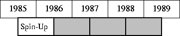 FIG. 3.1 The distribution contains forcing from August 1, 1985, through July 31, 1989 (lower bar). The first 12 month period is to be used as model spin-up, while the remaining three years (shaded region) are to be reported. Temporal Interpolation and Spin UpThe atmospheric forcing data are to be linearly interpolated from the three hour time step down to the model time step, except for the solid and liquid precipitation rates, which are to be held constant over the three-hour time interval. We request that modelers use time steps in their models of no more than three hours (we assume that the majority will run with time steps considerably smaller than this). The first forcing values correspond to the initial state (there are 365 x 8 + 1 time steps for the first year: 1987-1988 is a leap year so there are 366 x 8 time periods), all other values correspond to the end of the current three-hour time step. Snow cover and soil ice should be initialized at zero at the start of the spin-up year (August 1, 1985-July 31, 1986). The models are then requested to ``spin-up'' repeatedly using the first 365 days of the provided data. It is possible that snow will remain throughout the year in some models at some of the higher elevation points. Once a reasonable equilibrium state has been achieved, we ask that the modelers simulate the remaining three years. We ask that the groups only report results for the last three years. Experiment 1: The Entire DomainThe first experiment consists of running the SVAT scheme for the 1471 grid points for at least 1 year of spin-up, and then for the remaining three years which are to be reported. We ask that all modelers use the provided forcing (Table 3.9) and the mandatory parameter datasets (shown in Table 3.1): other parameters either included in the distribution (such as rooting depth, wilting point water content, etc.) or not listed are up to the discretion of the modelers. The effective parameters on the distribution may be used, or the modelers can calculate their own effective parameters using the correspondence data. Model results will be used to calculate the river discharge with the MODCOU model at CNRM. The results will be compared to the daily observed stream-flow at various gauging stations. The modeled snowpack depth will also be compared with the observations, and the various model results will be inter-compared. This simulation will serve as the high resolution baseline result. Experiment 2: Aggregated grid boxesThe second experiment consists of three simulations at two different grid resolutions. In the first test (Experiment 2a), each SVAT scheme is to be run over the same 4-year period for 20 sub-areas of the Rhône basin. The boundaries for each of these areas is determined using a 1 x 1 degree grid (which is consistent with the grid configuration used by the GSWP). The approximate divisions are shown in Fig. 3.1, and the actual mask is shown on the left panel of Fig. 3.2. We provide the area-average forcing and aggregated parameters for each of these sub-areas. The surface parameters have been aggregated for the 1 x 1 degree grid using the basic rules which are outlined later in this chapter together with the provided 8 x 8 km effective parameters (as opposed to the correspondence tables). The provided effective soil hydraulic parameters for the 1 x 1 degree grid are calculated using the grid box average soil texture, however, modelers may use other methods for aggregation (such as directly aggregating the 8 x 8 gridded soil hydraulic parameters, etc.). In addition, we have provided the mask for the sub-areas so that modelers may either use the default aggregated parameters, or they may aggregate the vegetation parameters and soil texture as they see fit. They may use the masks to define statistical distributions of topography, soils, etc., or to define sub-grid mosaics or tiles. We ask that participants running tile-type schemes only report the basin average output variables. The purpose of this experiment is to see the impact of changing the spatial scale from 8x8 km to that of a relatively high resolution climate model (and the same scale used in GSWP) on the simulations of the various hydrological components. 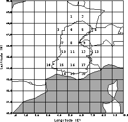 FIG. 3.2 The Rhône basin model domain (outlined area) together with the GSWP grid. The 20 boxes for Experiment 2 are indicated. The second test (Experiment 2b) consists of running the scheme in the same manner as in Experiment 2a, but for 60 approximately 1/2 x 1/2 degree grid boxes. As in Experiment 2a, aggregated forcing will be provided, and modelers may use either the provided aggregated parameters or their own set of aggregated parameters (based on their 8 x 8 km values). The purpose of this experiment is to examine an intermediate spatial scale in order to give a basic idea of whether the impact of scaling is linear, nonlinear, etc. 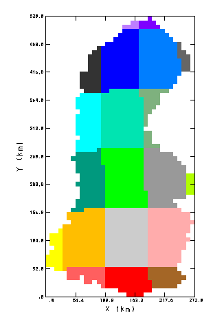 FIG. 3.3a The Rhône basin model domain grid mask for Experiment 2a using a 1.0 degree grid. 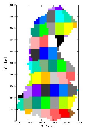 FIG. 3.3b The Rhône basin model domain grid mask for Experiment 2b using a 0.5 degree grid. A third test (Experiment 2c) consists of running the scheme in the same manner and grid configuration as in Experiment 2a, but using the dominant parameters only. We will provide the dominant parameters for this experiment, and the forcing from Experiment 2a will be used. Mosaic type schemes are to run this simulation with one tile for each grid box (using the dominant parameters). The goal of this experiment is to examine the impact of using effective verses dominant parameters. Experiment 3: Aggregated BasinsThe aggregated forcing (including the fractional coverage of liquid and solid precipitation at each three hour time step) and surface/soil parameters are provided for three sub-catchments within the Rhône basin, so that this experiment consists in running your SVAT model for 3 separate stand-alone or point simulations. The sub-basin masks are shown in Fig. 3.4: the sub-basins are for the Ardeche, Saone and Durance rivers. The main interests of this experiment are that the basin-scale simulated discharge can be directly compared to the observations, and the basins comprise three distinct climate regimes: the Ardeche has relatively light snowfall and heavy convective rainfall in the summer, the Saone is representative of a continental climate, and the Durance is a relatively high altitude basin (the mean altitude is approximately 2000 m) which receives considerable snowfall. As in Experiment 2, we provide the mask for the three basins so that modelers may either use the default aggregated parameters, or they may aggregate the vegetation parameters and soil texture as they see fit. As in Experiment 2, we ask that participants running tile-type schemes report only the basin average output variables. 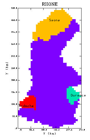 FIG. 3.4 The three sub-basins within the Rhône basin model domain used for Experiment 3: the Ardeche, the Durance and the Saone. See Table 3.1 for basin characteristics.
CalibrationThe stream flow data will be provided for two relatively small contrasting catchments within the Rhône basin over the four-year simulation period. Two masks are provided on the distribution so that modelers can extract the needed parameters and forcing from the 8 x 8 km grid data. In addition, a file containing the contributing area for each of the 8 x 8 km grid boxes for the two basins is provided so that modelers can calculate the total runoff corresponding to the calibration basins. The observed discharge has units of m3 s-1, so that modelers will need to convert their total runoff using the contributing area fractions. The model simulated total runoff (surface and sub-surface or drainage) for a given time period can be evaluated using this data without the use of the routing model. Please note: the contributing area fraction is only to be used for calibration, it is not to be used in the computation of the model runoff data which is to be reported as output (to us). The calibrated hydrological parameters can then be extrapolated over the entire domain however the modelers prefer for Experiment 1, and they can be aggregated as modelers wish for Experiments 2 and 3. However, we ask that the parameters in Table 3.1 not be changed from the provided values. Please note that calibration is not mandatory, and that by default the results are included in Experiment 1, output (we request no additional calibration output). We would like each participant group to provide us with a brief description as to which/what parameters were calibrated, how they were extrapolated over the domain, and how they were aggregated for Experiments 2 and 3. EvaluationThe simulated gridded total daily surface runoff and baseflow/drainage (Qs and Qsb, respectively: see Chapter 5) will be collected and used at CNRM as inputs into the distributed hydrological model MODCOU. The simulated runoff will then be compared directly with observations. We initially plan on using several standard metrics: the correlation (squared), the efficiency or Nash coefficient (Nash and Sutcliffe, 1970), the Root Mean Square error (RMS) and the ratio of the simulated to the observed discharge. We will also compare the simulated grid-box daily average snow depths with the observed values. The discharge obtained using the aggregated forcing and parameters will be compared to the observations (Experiment 3, and Experiment 2 for entire basin) and to the discharge simulated in Experiment 1. Other standard outputs (such as surface fluxes, soil moisture, SWE, etc.) will also be compared with those from Experiment 1. InitializationThe models are to assume that initially there is no snow cover and no soil ice (on August 1). Note that some higher altitude points may retain snow cover throughout the year. Because the simulations begin in mid-to-late summer, we recommend models initialize their root-zone soil moisture stores using the following relationship:
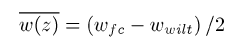
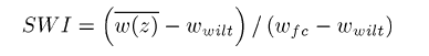
where the left-hand-side of Eq. 3.9 represents the average volumetric water content (m3 m-3) from the surface down to the base of the root-zone soil layer. This corresponds to SWI/2, where the Soil Wetness Index is defined as
It is recommended that sub-root zone layers be initialized using a water content w in the range wwilt <= w <= wfc. The soil temperature profile can be initialized using the average annual air temperature as a first guess. |