Front Page
General Information
The latest package version is [CaMa-Flood v4.20] (20240430)
CaMa-Flood v4.20 is the latest public release version.
Major update in v4.2
- Reservoir Operation Scheme as default option
Major update in v4.1
- MPI/OpenMP hybrid parallelization
- Single Precision Mode
Major update in v4.0 (compared to previous v3.6)
- Baseline topography is updated. Now it is based on MERIT Hydro (Yamazaki et al. 2019)
- FLOW upscaling algorithm is being updated (in prep)
- The model core dynamics is almost similar with the previsous version (v3.6).
- More flexible code structure in model coupling.
Description paper of v4
Some papers using CaMa-Flood v4 are now in press or under review. We will put the info on description papers soon.
Example of CaMa-Flood Simulation
Hydrodynamic simulation by CaMa-Flood (v4.0).
Calculation at 0.1 degree resolution, flood depth is diagnostically downscaled to 90m resolution DEM. Simulation of new topography (v4.00, right), compared to old topography (v3.6 replicate, left)
Introduction
The CaMa-Flood (Catchment-based Macro-scale Floodplain) model is designed to simulate the hydrodynamics in continental-scale rivers. The entire river networks of the world are discretized to the hydrological units named unit-catchments for achieving efficient flow computation at the global scale. The water level and flooded area are diagnosed from the water storage at each unit-catchment using the sub-grid topographic parameters of the river channel and floodplains. By adapting gird-vector hybrid river network map which corresponds one irregular-shaped unit-catchment to one grid-box, both realistic parameterization of sub-grid topography and easy analysis of simulation results are achieved. The river discharge and flow velocity are calculated with the local inertial equation along the river network map which prescribes the upstream-downstream relationship of unit-catchments. The time evolution of the water storage, the only one prognostic variable, is solved by the water balance equation which considers inflow from the upstream cells, outflow to the downstream cell and input from runoff forcing at each unit-catchment. Bifurcation of river channels can be also represented by analyzing high-resolution topography. The detailed description of the CaMa-Flood model is found in the description papers.
License to use CaMa-Flood model
CaMa-Flood is distributed under the below licenses.
Model Package: The model package contains both data and code. Please follow the license for each component
Model source code: The codes for hydrodynamic calculation (source code in src/ lib/ mod/ etc/) will be distributed with Apache 2.0 license.
Basic Map Data: The basic river map (without 3sec & 15sec data) will be distributed with CC-BY 4.0 license.
Advanced Maps with 3sec & 15sec data: The advanced river map (with 3sec data) can be shared by a request (with a special agreement depending on the purpose of use). Please contact to the developer.
Registration for Download
Please fill the Google Form to get an access to CaMa-Flood package.
or please contact to the developer (yamadai [at] iis.u-tokyo.ac.jp) if Google Form does not work well for you.
Need Help?
Even though the CaMa-Flood model is provided free-of-charge, it does not mean support for model usage is also free. If you asked any help in installing/running/analysing CaMa-Flood, proper consideration is requested to compensate developers' working time used for the requested help. Co-authorship in publications is ideal, but acknowledgement in journal papers is adequate for a small help.
I (Developer: Dai Yamazaki) am always happy for launching collaborative researches. If you want to have discussion with model developers on the results aquired from CaMa-Flood simulations, please feel free to invite me to your research team.
Code & Data
v4.2 Manual
The manual is not finalized, but the tentative version is available: CaMa-Flood v4.20 Manual
CaMa-Flood GitHub repository
The code/script of CaMa-Flood v4 is available on GitHub repository
NOTE: GitHub is for expert users who want to contribute to development. For general users, we recommend to use CaMa-Flood package below.
CaMa-Flood package
The model package (with source code, basic map data, and sample input data) is available.
Download CaMa-Flood package v4.20
CaMa-Flood river topography maps
NOTE: River maps are same in v4.2, v4.1 & v4.0
The global river map based on MERIT Hydro is available at 15min, 6min, 5min, 3min, 1min resolutions. They contains river network map, river topography parameters, high-resolution topography data (1min).
- Global 15min map:glb_15min.tar.gz
- Global 6min map: glb_06min.tar.gz
- Global 5min map: glb_05min.tar.gz
- Global 3min map: glb_03min.tar.gz
- Global 1min map: glb_01min.tar.gz
The high-accuracy river map for Japan based on "J-FlwDir (Japan Flow Direction Map) is also available at 3min & 1min resolutions.
- Japan 3min map: jpn_03min.tar.gz
- Japan 1min map: jpn_01min.tar.gz
River gauge allocation tool
A tool to allocate river gauges on MERIT Hydro and CaMa-Flood river map is prepared. Allocation consists of two steps. Step-(1) Allocation on 30sec MERIT Hydro, and Step-(2) Allocation on CaMa-Flood river map.
A package containinig source code, map data, and documentation is available from below link.
- latest version of AllocRiverGauge is v1.2 (2024.11.22)
Download AllocRiverGauge_v1.2_20241122.tar.gz
Additional Data (External)
Pre-processed Input for CaMa-Flood
We have processed Earth2Observe (E2O) runoff products for use in CaMa-Flood. (0.25deg, daily, 1980-2014, WRR2 version, 7 Land models.)
The original data is distributed in E2O webpage, under CC-BY-SA 4.0 license.
The processed runoff data is also distributed under CC-BY-SA 4.0 license.
The modifications we applied are:
- change of sign (runoff is defined as a negative flux in oroginal E2O)
- make sure the unit was the same for all (mm/day)
- make sure the orientation (south to north) and grid (60S to 90N) was the same for all.
- set negative runoff values to zero in the JULES and ORCHIDEE data.
For detail, please read the description paper:
Original description: Schellekens et al. 2017; Dutra et al. 2017.
Data processing (by Dirk Eilander): Eilander et al., 2020
If you want to do simulations with E2O runoff data, please downlaod it from below. (note: each is ~10GB).
- E2O_WRR2 ECMWF HTESSEL: E2O_ecmwf.tar
- E2O_WRR2 NERC JULES: E2O_nerc.tar
- E2O_WRR2 CNRS ORCHIDEE: E2O_cnrs.tar
- E2O_WRR2 JRC LISFLOOD: E2O_jrc.tar
- E2O_WRR2 ANU W3: E2O_anu.tar
- E2O_WRR2 U-Kassel WaterGAP: E2O_univk.tar
- E2O_WRR2 U-Utrech PCR-GLOBWB: E2O_univu.tar
Runoff climatology
The runoff climatology data is needed to calculate river channel parameters (already included in the package, so no need to download if you are using package). If you want this data for some reasons, please download from here.
Model Description
Overall Framework
The CaMa-Flood (Catchment-based Macro-scale Floodplain) model is a global-scale distributed river model, which is driven by runoff forcing from a land surface model. The water storage at each grid cell is the only prognostic variable, while the other variables (i.e. water level, inundated area, river discharge, and flow velocity) are diagnosed from the grid cell water storage at each time step. The time evolution of water storage at every time step is solved by calculating the water flux (discharge) between each grid cell and the next downstream cell along a prescribed river network. River discharge and flow velocity are estimated by the local inertial equation.
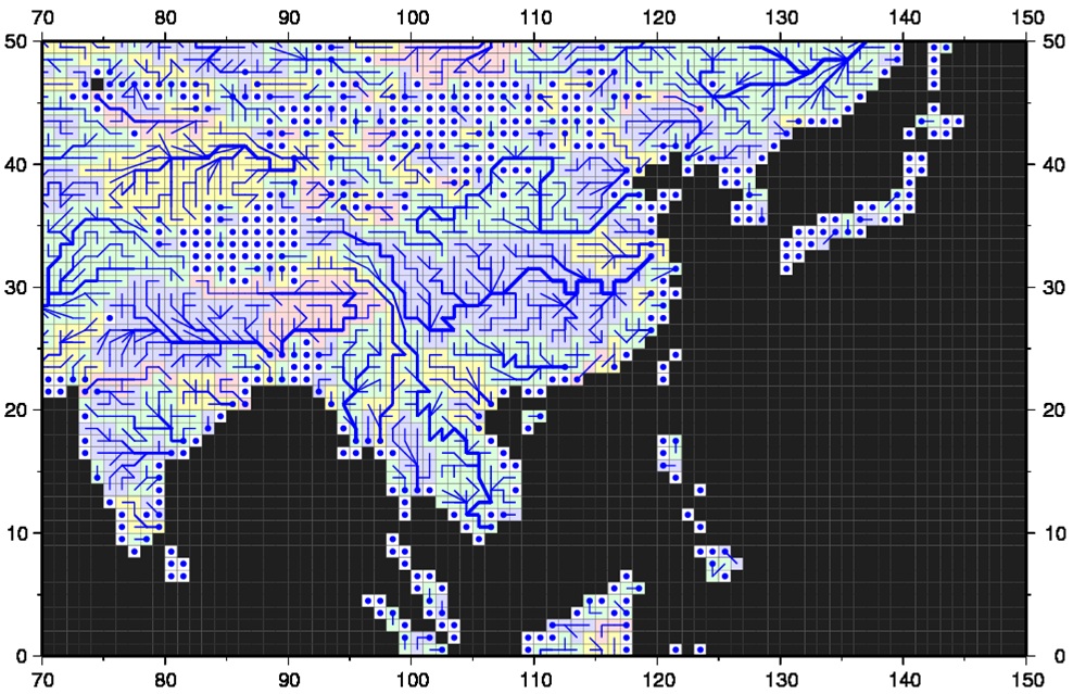
Figure 1: River Network Map.
In order to represent the process of floodplain inundation, the river channel and floodplain topography are represented by sub-grid-scale topographic parameters (Figure 2a). The ground elevation, Z , unit-catchment area, Ac , channel length, L , and floodplain elevation profile are explicitly derived from fine-resolution flow direction maps and DEMs using the FLOW method. The floodplain elevation profile is a function that describes the relationship between the water level and inundated area for each grid cell (Figure 2c), and is created by calculating the cumulative distribution function (CDF) of the height of each fine-resolution pixel above the nearest downstream river channel pixel within each unit-catchment (Figure 2b).
The channel cross section parameters (i.e. channel width, W, and channel depth, B) are derived empirically as a function of river discharge due to the lack of global-scale observations of channel cross sections.
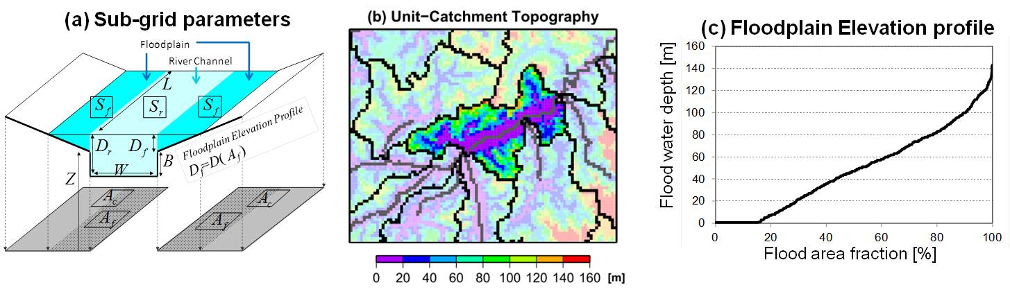
Figure 2: Sub-grid Topographical Parameters.
References / Related Papers
Description Papers
A physically-based description of floodplain inundation dynamics in a global river routing model
Dai Yamazaki, Shinjiro Kanae, Hyungjun Kim, & Taikan Oki
Analysis of the water level dynamics simulated by a global river model: A case study in the Amazon River
Dai Yamazaki, Hyongki Lee, Douglas E. Alsdorf, Emanuel Dutra, Hyungjun Kim, Shinjiro Kanae, & Taikan Oki
Improving computational efficiency in global river models by implementing the local inertial flow equation and a vector-based river network map
Dai Yamazaki, Gustavo A. M. de Almeida, & Paul D. Bates
Regional flood dynamics in a bifurcating mega delta simulated in a global river model
Dai Yamazaki, Tomoko Sato, Shinjiro Kanae, Yukiko Hirabayashi, & Paul D. Bates
A high-accuracy map of global terrain elevations
Dai Yamazaki, Daiki Ikeshima, Ryunosuke Tawatari, Tomohiro Yamaguchi, Fiachra O'Loughlin, Jeff C. Neal, Christopher C. Sampson, Shinjiro Kanae, and Paul D. Bates
MERIT Hydro: A high-resolution global hydrography map based on latest topography datasets
Yamazaki, D., D. Ikeshima, J. Sosa, P.D. Bates, G.H. Allen, T.M. Pavelsky
Applications (Flood Risk Assessment)
Global flood risk under climate change
Yukiko Hirabayashi, Roobavannan Mahendran, Sujan Koirala, Lisako Konoshima, Dai Yamazaki, Satoshi Watanabe, Hyungjun Kim, & Shinjiro Kanae
Deriving global flood hazard maps of fluvial floods through a physical model cascade
Pappenberger, F., Dutra, E., Wetterhall, F., & Cloke, H. L.
Modeling complex flow dynamics of fluvial floods exacerbated by sea level rise in the Ganges-Brahmaputra-Meghna delta
Hiroaki Ikeuchi, Yukiko Hirabayashi, Dai Yamazaki, Masashi Kiguchi, Sujan Koirala, Takanori Nagano, Akihiko Kotera, and Shinjiro Kanae
Assessing the impacts of reservoir operation to floodplain inundation by combining hydrological, reservoir management, and hydrodynamic models
C.M. Mateo, N. Hanasaki, D. Komori, K. Tanaka, M. Kiguchi, A. Champathong, T. Sukhapunnaphan, D. Yamazaki, T. Oki
The spatial exposure of the Chinese infrastructure system to flooding and drought hazards
Hu, X., Hall, J. W., Shi, P., and Lim, W. H.
Applications (Climate & Biogeochemistry)
A large-scale methane model by incorporating the surface water transport
Lu, X., Q. Zhuang, Y. Liu, Y. Zhou, and A. Aghakouchak
Development and evaluation of a new regional coupled atmosphere-ocean model in the North Sea and Baltic Sea.
Wang, S., Dieterich, C., Doscher, R., Hoglund, A., Hordoir, R., Meier, H. M., ... & Schimanke, S
Global assessment of agreement among streamflow projections using CMIP5 model outputs.
Koirala, S., Hirabayashi, Y., Mahendran, R., & Kanae, S.