FrontPage
General Information
Note
The latest version is CaMa-Flood_v3.6.2 (9 August,2014)
Some bugs in v3.6.1 are fixed. Please read the manual for detailed changes.
The detailed description of the CaMa-Flood global river model (ver 3.6.2) is summarized in the User's Manual of CaMa-Flood.
Example of CaMa-Flood Simulation
Hydrodynamic simulation by CaMa-Flood (v3.6).
Calculation at 0.1 degree resolution, flood depth is diagnostically downscaled onto 500m resolution DEM.
Introduction
The CaMa-Flood (Catchment-based Macro-scale Floodplain) model is designed to simulate the hydrodynamics in continental-scale rivers. The entire river networks of the world are discretized to the hydrological units named unit-catchments for achieving efficient flow computation at the global scale. The water level and flooded area are diagnosed from the water storage at each unit-catchment using the sub-grid topographic parameters of the river channel and floodplains. By adapting gird-vector hybrid river network map which corresponds one irregular-shaped unit-catchment to one grid-box, both realistic parameterization of sub-grid topography and easy analysis of simulation results are achieved. The river discharge and flow velocity are calculated with the local inertial equation along the river network map which prescribes the upstream-downstream relationship of unit-catchments. The time evolution of the water storage, the only one prognostic variable, is solved by the water balance equation which considers inflow from the upstream cells, outflow to the downstream cell and input from runoff forcing at each unit-catchment. Bifurcation of river channels can be also represented by analyzing high-resolution topography. The detailed description of the CaMa-Flood model is found in the description papers.
The major advantage of the CaMa-Flood simulations is the explicit representation of flood stage (water level and flooded area) in addition to river discharge. In addition to traditional model validation with gauged river discharge, it is possible to make a direct comparison between model simulations and satellite observations. Observations of water surface elevation by satellite altimeters and/or flooded area by SAR and microwave imagers are very useful to enhance the calibration/validation of the global river model. Explicit representation of flooded area is helpful for flood damage assessment by overlaying it with socio-economic datasets. The assimilation of observed flood stage into the CaMa-Flood simulation is a potential research topic, for optimizing model parameters and extending the forecast skill for near future flooding.
Another advantage of the CaMa-Flood model is its high computational efficiency of the global river simulations. The complexity of the floodplain inundation processes is reasonably approximated to a diagnostic scheme at the scale of a unit-catchment by introducing the sub-grid topographic parameters. The cost of the prognostic computation of river discharge and water storage is optimized by implementing the local inertial equation and the adaptive time step scheme. The high computational efficiency of the CaMa-Flood model is beneficial for computational demanding experiments such as ensemble/long-term experiments and dynamic coupling between river routine and other hydrological schemes.
Model Distribution
Terms and Conditions
Agreement to Terms and Conditions is required for using CaMa-Flood.
Please note that CaMa-Flood is provided for free of charge, only for non-commertial academic purposes (academic research and education). Permission is needed if CaMa-Flood is used for other purposes (e.g. commercial use).
Please e-mail to the developer to acquire password for downloading CaMa-Flood. Please describe your name, research institute, and purpose of using CaMa-Flood.
Dai YAMAZAKI: yamadai [at] rainbow.iis.u-tokyo.ac.jp
Need Help?
Even though the CaMa-Flood model is provided free-of-charge, it does not mean support for model usage is also free. If you asked any help in installing/running/analysing CaMa-Flood, proper consideration is requested to compensate developers' working time used for the requested help. Co-authorship in publications is ideal, but acknowledgement in journal papers is adequate for a small help.
I (Developer: Dai Yamazaki) am always happy for launching collaborative researches. If you want to have discussion with model developers on the results aquired from CaMa-Flood simulations, please feel free to invite me to your research team.
CaMa-Flood manual
Model description and usage are written in the manual.
Download the CaMa-Flood manual
CaMa-Flood v3.6.2 main package
The main package include model source codes, executable scripts, global river map at 0.25 degree resolution, regionalization tools, and sample input data.
Download the CaMa-Flood v3.6.2 main package
Bug-fix patch for v3.6.1 (src, lib)
If you are using v3.6.1, please replace the src and lib for bug fix.
Download bug-fix patch for v3.6.1
High-resolution original data
The original high-resolution data are required for channel bifurcation scheme. The high-resolution data includes river network map, drainage area, elevation, channel width at 0.005 degree resolution.
If the original high-resolution data is needed, please download the sheds_0.005_140815.tar.gz archive, unzip and extend the archive, and put it on $CaMa-Flood/map/ directory. Then make a symbolic link in, for example, $CaMa-Flood/map/global_15min/ directory by "% ../sheds_0.005_140807 sheds".
Download the original high-resolution data
0.1deg/0.5deg River Network Maps
Higher/lower resolution river network maps are prepared. If needed, please download these maps and put them on $CaMa-Flood/map/ directory.
A river network map at another resolution (or another grid coordination) may be available on request.
Download 0.1deg river network map
Download 0.5deg river network map
Model Description
Model Description PPT
PPT slides for brief model description is available. You can know what assumptions are used in CaMa-Flood to realize fast and realistic global hydrodynamic simulations.
Download the PPT slide
Overall Framework
The CaMa-Flood (Catchment-based Macro-scale Floodplain) model is a global-scale distributed river model, which is driven by runoff forcing from a land surface model. The water storage at each grid cell is the only prognostic variable, while the other variables (i.e. water level, inundated area, river discharge, and flow velocity) are diagnosed from the grid cell water storage at each time step. The time evolution of water storage at every time step is solved by calculating the water flux (discharge) between each grid cell and the next downstream cell along a prescribed river network. River discharge and flow velocity are estimated by the local inertial equation.
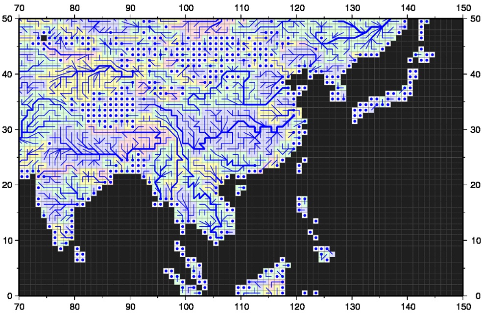
Figure 1: River Network Map.
In order to represent the process of floodplain inundation, the river channel and floodplain topography are represented by sub-grid-scale topographic parameters (Figure 2a). The ground elevation, Z , unit-catchment area, Ac , channel length, L , and floodplain elevation profile are explicitly derived from fine-resolution flow direction maps and DEMs using the FLOW method. The floodplain elevation profile is a function that describes the relationship between the water level and inundated area for each grid cell (Figure 2c), and is created by calculating the cumulative distribution function (CDF) of the height of each fine-resolution pixel above the nearest downstream river channel pixel within each unit-catchment (Figure 2b).
The channel cross section parameters (i.e. channel width, W, and channel depth, B) are derived empirically as a function of river discharge due to the lack of global-scale observations of channel cross sections.
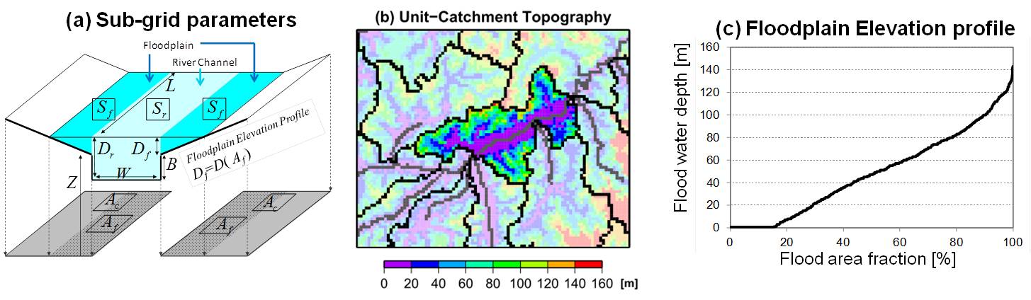
Figure 2: Sub-grid Topographical Parameters.
References / Related Papers
Description Papers
A physically-based description of floodplain inundation dynamics in a global river routing model
Dai Yamazaki, Shinjiro Kanae, Hyungjun Kim, & Taikan Oki
Analysis of the water level dynamics simulated by a global river model: A case study in the Amazon River
Dai Yamazaki, Hyongki Lee, Douglas E. Alsdorf, Emanuel Dutra, Hyungjun Kim, Shinjiro Kanae, & Taikan Oki
Improving computational efficiency in global river models by implementing the local inertial flow equation and a vector-based river network map
Dai Yamazaki, Gustavo A. M. de Almeida, & Paul D. Bates
Regional flood dynamics in a bifurcating mega delta simulated in a global river model
Dai Yamazaki, Tomoko Sato, Shinjiro Kanae, Yukiko Hirabayashi, & Paul D. Bates
Applications (Flood Risk Assessment)
Global flood risk under climate change
Yukiko Hirabayashi, Roobavannan Mahendran, Sujan Koirala, Lisako Konoshima, Dai Yamazaki, Satoshi Watanabe, Hyungjun Kim, & Shinjiro Kanae
Deriving global flood hazard maps of fluvial floods through a physical model cascade
Pappenberger, F., Dutra, E., Wetterhall, F., & Cloke, H. L.
Modeling complex flow dynamics of fluvial floods exacerbated by sea level rise in the Ganges-Brahmaputra-Meghna delta
Hiroaki Ikeuchi, Yukiko Hirabayashi, Dai Yamazaki, Masashi Kiguchi, Sujan Koirala, Takanori Nagano, Akihiko Kotera, and Shinjiro Kanae
Assessing the impacts of reservoir operation to floodplain inundation by combining hydrological, reservoir management, and hydrodynamic models
C.M. Mateo, N. Hanasaki, D. Komori, K. Tanaka, M. Kiguchi, A. Champathong, T. Sukhapunnaphan, D. Yamazaki, T. Oki
The spatial exposure of the Chinese infrastructure system to flooding and drought hazards
Hu, X., Hall, J. W., Shi, P., and Lim, W. H.
Applications (Climate & Biogeochemistry)
A large-scale methane model by incorporating the surface water transport
Lu, X., Q. Zhuang, Y. Liu, Y. Zhou, and A. Aghakouchak
Development and evaluation of a new regional coupled atmosphere-ocean model in the North Sea and Baltic Sea.
Wang, S., Dieterich, C., Doscher, R., Hoglund, A., Hordoir, R., Meier, H. M., ... & Schimanke, S
Global assessment of agreement among streamflow projections using CMIP5 model outputs.
Koirala, S., Hirabayashi, Y., Mahendran, R., & Kanae, S.