Frontpage
General Information
New version v1.4 / バージョン更新 v1.4
v1.3のコードにバグがありました。n34e131とn33e130のタイルのエラーを修正しました。
(1 Dec, 2022)
Product Info / プロダクト情報
"Japan Flow Direction Map" is developed by the University of Tokyo and Kyoto University,
mainly based on the national elevation data and water map from GSI (GeoSpatial Information Authority of Japan).
The primary data is the 'flow direction map (local drainage direction)',
and supplementary dataset consistent to the flow directions are also prepared.
The supplementary datasets include
- 'hydrologically adjusted elevations'
- 'upstream drainage area (flow accumulation area)'
- 'upstream grid numbers (flow accumulation grids)'
- 'river channelwidth'.
『日本域表面流向マップ』は主に国土地理院の「国土数値情報」「基盤地図情報」を用いて,
東京大学と京都大学が開発した高解像度水文地形データセットです.
主要なデータは各ピクセルにおける表面流の流下方向を示す「表面流向データ」で,
さらに表面流向と整合性のとれた水文地形データレイヤを整備しました.
水文地形データレイヤは, 「水文補正標高」「上流集水面積」「上流集水ピクセル」「河道幅」が含まれます.
Abstract of Data Development / データ開発概要
We developed a new surface flow direction datasets at 1-sec (~30m) resolution for the entire Japan domain, using “Kiban Chizu Joho” digital elevation model, “Kokudo Suchi Joho” water body layers and "G1WBM" landsat water body map. The calculation of flow directions for a large domain used to be difficult due to errors in the input elevation data. We solved this problem by a new algorithm, which first calculate the initial-guess flow directions by a steepest slope method, and then ensure river connectivity by reversing the initial-guess flow directions when needed. The new flow direction data shows better consistency to the accrual river networks compared to the previous HydroSHEDS flow directions. We also generated supplementary data layers such as flow accumulation area, adjusted elevation, and river width. The new flow direction datasets is considered to advance any geoscience studies which relies on flow direction data.
-- The full description paper is available in SUIKO joural (In Japanese with English abstract).
-- Yamazaki et al. (2018) "HIGH-RESOLUTION FLOW DIRECTION MAP OF JAPAN"
-- Journal of Japan Society of Civil Engineers (B1), vol.74(5), I_163-I_168
基盤地図情報 標高データ, 国土数値情報 水域データ, G1WBM Landsat水面マップを用い,日本全域1秒(約30m)解像度で各ピクセルにおける地表水流下方向を表す表面流向データを整備した.
標高データに含まれる誤差などのために広域での表面流向データ開発は困難と考えられていたが,
最急勾配法で算定した表面流向を必要に応じて逆転させるアルゴリズムの開発によって効率的な表面流向計算を実現した.
入力データの高精度化と計算手法の改良により,開発した日本域表面流向データは既存のHydroSHEDSなどと比較して
正確かつ詳細な河道ネットワークを表現することを確かめた.
また,表面流向に加えて上流集水面積・水文補正標高・河道幅などの付加的データも,変数間の整合性が取れるように整備した.
開発した表面流向データは水工学に限らず多様な地球科学分野への応用が期待できる.
-- 山崎大, 冨樫冴佳, 竹島滉, 佐山敬洋 (2018) 日本全域高解像度の表面流向データ整備
-- 土木学会論文集B1 (水工学), 75巻5号, I_163-I_168
Input Data Sources / 入力データソース
Digital Elevation Data / 標高データ
[GSI] Digital Elevation Model / 国土地理院 基盤地図情報 数値標高モデル
GSI DEM webpage
Water Body Data / 水面データ
[GSI] Digital National Map / 国土地理院 国土数値情報 水域データ
GSI National Map download page
[OpenStreetMap / U-Tokyo] OSM Water Body Layer
-- In Preparation --
[U-Tokyo] G1WBM: Landsat water body map
G1WBM web page
Data Description / データについて
Data Format / データ形式
The flow direction datasets is referenced to "WGS84" and "JapanGeoid2011 (GSIGEO2011 v2)".
The data is prepared as 1 degree x 1 degree tiles (3600 pixel x 3600 pixel).
Filename represents the lower-left corner of the lower-left pixel of the data domain; e.g. the file "n35e135_dem.tif" is for the DEM of the domain N35-N36, E135-E136.
The data format is geoTiff.
日本域表面流向マップは, WGS84座標系, JapanGeoid2011 (GSIGEO2011 v2)ジオイドに準拠しています.
ファイル名は, ドメインの左下ピクセルの左下角の座標を示します. 例えば "n35e135_dem.tif" はN35-N36, E135-E136の標高データです.
データフォーマットはGeoTiffです
Flow Direction (Local Drainage Direction) / 表面流向データ
Flow direction is prepared in 1-byte SIGNED integer (int8). The flow direction is represented as follows.
NOTE: If a flow direction file is opened as UNSIGNED integer, undefined=247 and inland depression=255
1: east, 2: southeast, 4: south, 8: southwest, 16: west, 32: northwest, 64: north. 128: northeast
0: river mouth, -1: inland depression, -9: undefined (ocean)
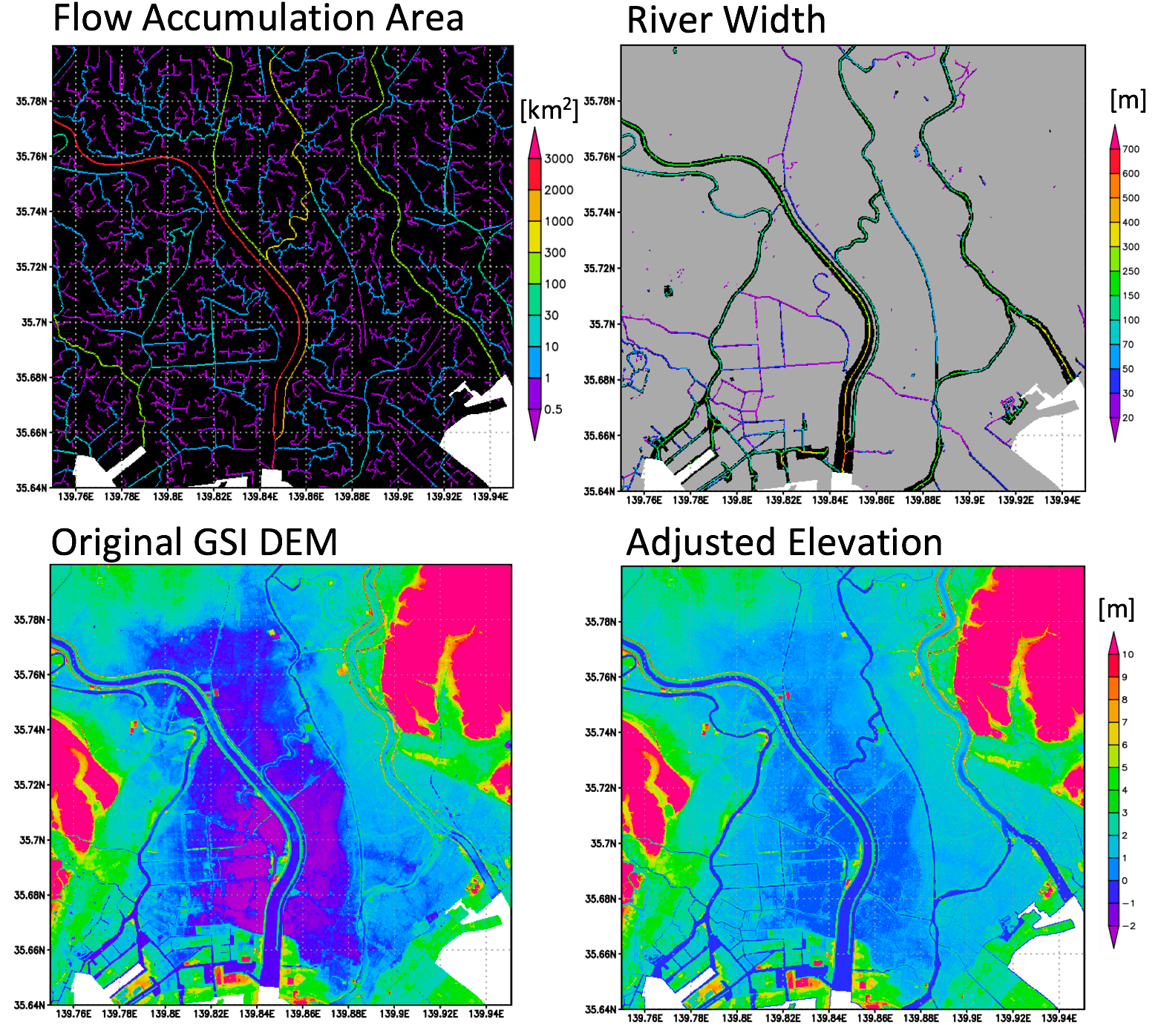
Hydrologically Adjusted Elevations / 水文補正標高
Adjusted elevation is reprepared in 4-byte float (float32). The elevations are adjusted to satisfy the condition 'downstream is not higher than its upstream' while minimizing the required modifications from the original DEM.
The elevation above EGM96 geoid is represented in meter, and the vertical increment is set to 10cm. The undefined pixels (oceans) are represented by the value -9999.
For detailed method, see [Yamazaki et al., 2012, WRR].
Upstream Drainage Area (Flow Accumulation Area) / 上流集水面積
Drainage area is reprepared in 4-byte float (float32). The drainage area is represented in km2.
The undefined pixels (oceans) are represented by the value -9999.
Upstream Grid Number (Flow Accumulation Grid) / 上流集水グリッド数
Number of upstream grids is reprepared in 4-byte integer (int32).
The undefined pixels (oceans) are represented by the value -9999.
River Channel Width / 河道幅
River width is reprepared in 4-byte float (float32), in meter. The values larger than 0 represents the river width at the channel centerlines. The value "-1" represents non-centerline water pixels, and the value "0" corresponds to the non-water pixels.
The undefined pixels (oceans) are represented by the value -9999.
River channel width is calculated by the method described in [Yamazaki et al. 2012, WRR], with some improvements/changes on the algorithm.
HAND: Height Above Nearest Drainage / 直近の河道からの相対高さ
HAND is reprepared in 4-byte float (float32), in meter. The values represent the height above nearest drainage [Noble et al., 2011, JoH]. Here, "drainage" is defined as pixels with upstream area >0.5km2.
The undefined pixels (oceans) are represented by the value -9999.
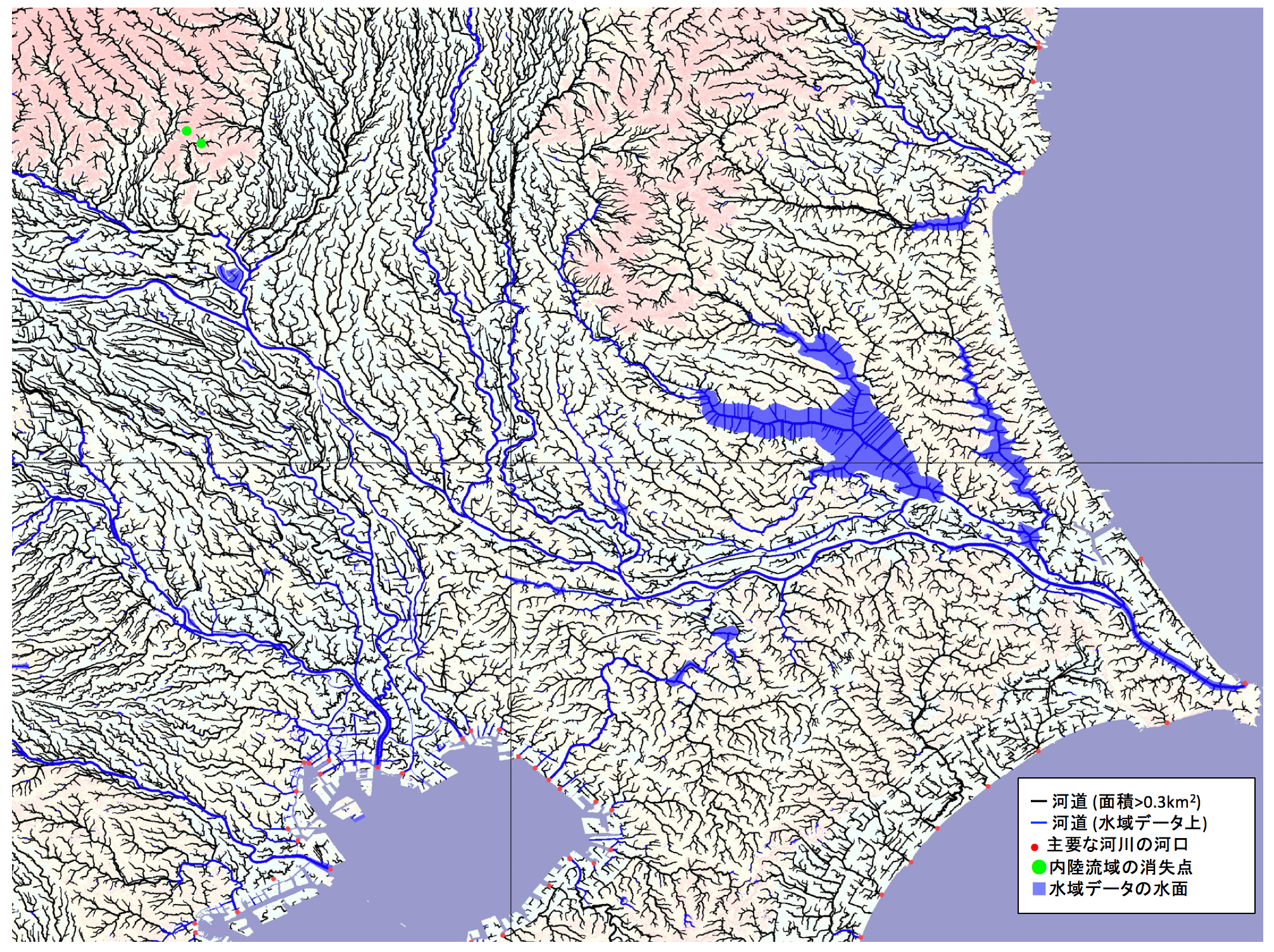
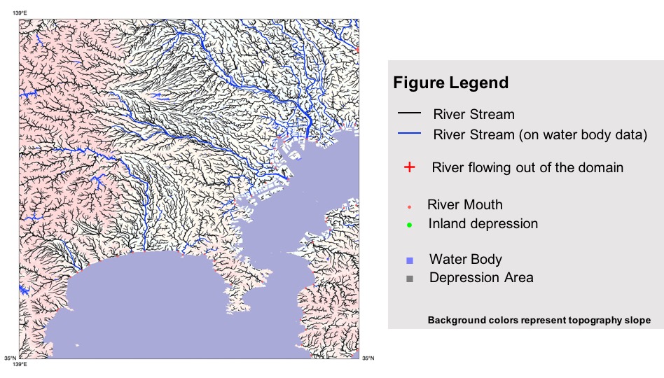
Quick Look Figure / 河道網の図
About Figure Archive (password not required)
クイックルック用の図については、パスワードは不要です
In order to quick look the product, the figures visualizing the river netowkrs are acceesible without password.
Please download the figure archive from the links below if you are interested in.
Download Figure Archive
Use of Data / データ使用について
License Agreement
"Japan Flow Direction Map" is licensed under a Creative Commons Attribution 4.0 International License (CC-BY 4.0). To view a copy of this license, please visit http://creativecommons.org/licenses/by/4.0/. By downloading and using the data the user agrees to the terms and conditions of this license. Notwithstanding this free license, we ask users to refrain from redistributing the data in whole in its original format on other websites without the explicit written permission from the authors. - "Japan Flow Direction Map" is available for download at http://hydro.iis.u-tokyo.ac.jp/~yamadai/JapanDir/. - The copyright of "Japan Flow Direction Map" is held by the developers, 2018, all rights reserved.
Data sharing policy
Citation to the paper is adequate if you simply use "Japan Flow Direction Map".
If you asked help for additional handling/editing of the dataset,
or your research outcome highly depends on the product,
the developer would request co-authorship.
[ Citation ]
The full description paper is available in SUIKO joural
Yamazaki D., S. Togashi, A. Takeshima, T. Sayama (2018)
"HIGH-RESOLUTION FLOW DIRECTION MAP OF JAPAN"
Journal of Japan Society of Civil Engineers (B1), vol.74(5), I_163-I_168
(In Japanese with English abstract)
ライセンス
"日本域表面流向マップ"はCreative Commons Attribution 4.0 国際ライセンス(CC-BY 4.0)でライセンスされます.
ライセンス条項のコピーは http://creativecommons.org/licenses/by/4.0/ で確認できます.
データをダウンロードすることで、ユーザーはライセンス条項に同意したとみなされます.
CC-BY 4.0は再配布可能なライセンスですが, バージョン管理などのため本WebPage以外で、
開発者からの許可を得ずに未加工データ全体をWebなどで再配布することは禁止します.
- "日本域表面流向マップ"は http://hydro.iis.u-tokyo.ac.jp/~yamadai/JapanDir/ からダンロードできます.
- "日本域表面流向マップ"の著作権は開発者に属します. (2018, all rights reserved).
データ共有ポリシー
"日本域表面流向マップ"を使用しただけの場合は, データ記述論文の引用で十分です.
データ使用にあたり開発者からの追加サポートを依頼した場合,
もしくは成果の大部分が"日本域表面流向マップ"に依存する場合は
発表論文などで開発者を共著に追加してください.
[ データ記述論文 ]
山崎大, 冨樫冴佳, 竹島滉, 佐山敬洋 (2018)
日本全域高解像度の表面流向データ整備
土木学会論文集B1 (水工学), 75巻5号, I_163-I_168
データに問題を見つけたら
"日本域表面流向マップ"には,入力データやアルゴリズムの不確実性による問題が含まれています.
明らかな河道網の間違いなどを見つけましたら,開発者まで連絡お願いします.適宜データを修正していきます.
User Registration / ユーザー登録
Please fill the Google Form to get an access to Japan Flow Direction Map
or please contact to the developer (yamadai [at] iis.u-tokyo.ac.jp) to get an access.
Google Formでユーザー登録すると 日本域表面流向データをダウンロードできます
フォームがうまく動作しない場合は, 開発者に直接メールしてください(yamadai [at] iis.u-tokyo.ac.jp).
Data Download / ダウンロード
Current version is v1.4 / 現在の最新版はv1.4です
[1 Dec, 2022]
UPDATE NOTE:
[v1.4] (1Dec, 2022)
Errors in n34e131 and n33e130 tiles are corrected.
[v1.31] (27 May, 2021)
Small bug fix on pixel size metadata due to precision error. (No change in the data itself.)
[v1.3] (30 Mar, 2021)
Error correction on some rivers. (No major update on code and input data).
[v1.0] (20 Nov, 2018)
Official Release. G1WBM Landsat water body was added as input data
-- Minor modification: Three tiles with "no data" are removed (n29e140, n31e139, n33e138). [21Nov,2018]
[v0.3] (16 June, 2018)
Bug fix in Ishikari River
[v0.2] (7 Mar, 2018)
Bug fix in adjusted elevations
[v0.1] (Jan, 2018)
First beta version release.
Flow Direction Map / 表面流向
Adjusted Elevation / 水文補正標高
Flow Accumulation Area / 上流集水面積
Flow Accumulation Pixels / 上流集水ピクセル数
River Channel Width / 河道幅
Height Above Nearest Drainage (HAND)
Original DEM before adjustment / 修正前のDEM
--- Old version archive v1.0 ---
Acknowledgement
「日本域表面流向マップ」は、「戦略的イノベーションプログラム(SIP)」の枠組みで開発・公開されています。
基盤地図情報は国土地理院の承認のもとで使用しています。「測量法に基づく国土地理院長承承認(使用)R3 JHs 511」
表面流向計算アルゴリズムは「統合的気候モデル高度化研究プログラム」で開発した全球データ用のコードを、SIP研究で日本域向けに最適化したものです。
v1.3でのエラー修正には、産業技術総合研究所の岩崎さんの科研プロジェクトによってJ-FlwDir精度に関する情報提供をいただきました。