Regional Hydrology

"Region" is a most fundamental unit of nature in hydrology. The role of the horizontal evapotranspiration within global area becomes less important in regional hydrology, and the runoff cycle between precipitation over land areas and subsequent discharge of this water through stream channnels or evapotranspiration is studied as a main topic.

Our laboratory have two types of study area: Evi river in Chiba prefecture in Japan for small and medium size catchments that are normally the case of rivers in Japan, and Chao Phraya river basin in Thailand for large catchment.

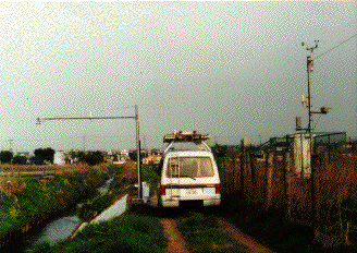
(Obsevation facility setted in Ebi river in Chiba prefectureD)

Urban Hydrology

Watershed urbanization strongly affects a river which has close relation to the cities in these days. Increase of uninfiltrated area together with the expantion of urban area causes serious flood disasters in terms of increase of peak discharge and decrease of concentration time of flood runoff.
Above this, concentration of population to cities will give rise to water pollution and decrease of average dischrage of river.
With this point of view, our laboratory have been examined the effection of watershed urbanization to the river with whole understanings of the existing state of urvanization and hydrologic cycle in urban area on the basis of observed data.

Microwave Remote Sensing

Surface soil moisture is the most important factor for studying an interactoin of atmosphere and land surface. Spatial informations of soil wetness will effectively help us to understand this interaction processes.
The backscattering coefficient observed by satellite-based microwave scatterometer are influenced by surface geometric roughness and surface soil wetness. It is expected that the spatial soil moisture informations can be obtained utilizing this backscattering data.
Experiments using a C band microwave scatterometer in both indoor and outdoor were carried out to clarify the characteristics of the soil backscatter from its surface at our laboratory, and ground-base verification experiments for the soil moisture detection by spaceborne SARs (E ERS-1 and J ERS-1) were also carried out.

Numerical Hydrology Model

A hydrologic system model is an approximation of the actual system; its inputs and outputs are measurable hydrologic variables conserning atmosphere, landsurface, and underground, and its structure is a set of equations linking the inputs and outputs. These models are usually calculated numerically by computer with use of data set obtained by latest technology such as microwave remote sensing and GIS. With use of these hydrologic system models, we can understand whole temporal and spatial hydrologic system, by forecasting, reproducing and estimating flood and drought.