GAME-T2 DataCenter : TMD Routine Observation
GAME Logo

TMD Routine Observation

GAME Logo GAME-T2 DataCenter
GAME-T2 >> DataCenter >> Routine Obs.  >> TMD (Current Position)

Introduction

TMD (Thai Meteorological Department) have been carried out operational weather observation at 80 normal sites and 30+ AGROMET stations. Followings are datasets derived from their measurement. All datasets are protected by password


Metadata

Normal Sites

Data Type DescriptionWeather Observation by TMD
Type Routine Observation Data
Period TypeIncluding IOP
HoldingInternational Data Resource (IOP) / Institutional Holding (others)
Process LevelLevel 2 (Station Data)
QC Levelunknown (depend on TMD's QC)
Access LimitationInside GAME-T only
Contents
  1. Rainfall [D, 3H, H]
  2. Evaporation [D]
  3. Max T [D]
  4. Min T [D]
  5. Sunshine Duration [D]
  6. Cloudiness [3H]
  7. Dry Bulb Temp [3H, H]
  8. Wet Bulb Temp [3H]
  9. RH [3H, H]
  10. Visibility [3H]
  11. Wind Speed[3H, 1H]
Spatial Range Point/Points/GridPoints
Location/ExtentAbout 80 Sites in Thailand
Temporal Range Period From 1992 to 2002 (* see note below)
IntervalDaily, 3-hourly, 1-hourly (* see note below)
LT / UTCLT
Time Difference (LT - UTC)+0700
Boundary0700LT (0000 UTC). (* see note below)
Contact Person
(See the list of contact persons for detail)
T.M.D., Prof. Matumoto, J., Prof. Oki, T. and Dr. Agata, Y.
Notes
  • Currently only rainfall datasets are opened to public
  • Letters 'D', '3H', '1H' in the 'contents' cell denote that daily, 3-hourly and 1-hourly data files are available for that item, respectively.
  • In 3-hourly datasets, data at 0100LST means total value from 2200LST in previous day to 0100 in current day. 0400LST data is accumulated amount between 0100-0400LST and so on
  • Daily rainfall data is defined as the total sum of 0700LST to 0700LST in next day (TMD definition)

XML Metadata File

AGROMET sites

Agrometeorological stations. Particularly useful values for agriculture are being intensively measured.

Data Type DescriptionWeather Observation by TMD (Agromet sites)
Type Routine Observation Data
Period TypeIncluding IOP
HoldingInternational Data Resource (IOP) / Institutional Holding (others)
Process LevelLevel 2 (Station Data)
QC Levelunknown (depend on TMD's QC)
Access LimitationInside GAME-T only
Contents
  1. Max T (degC)
  2. Min T (degC)
  3. Grass Min T (degC)
  4. Water Max T (degC)
  5. Water Min T (degC)
  6. Max RH (%)
  7. Min RH (%)
  8. Rainfall (mm)
  9. Pan Evaporation (mm)
  10. Dew at 10cm (mm)
  11. Wind Direction (8 orientation)
  12. Wind Speed (m/s)
  13. Soil Temperature at 0,5,10,20,50,100cm (degC)
  14. Sunshine Duration (hours)
Spatial Range Point/Points/GridPoints
Location/Extent34 Agromet Sites in Thailand
Temporal Range Period From 1997 to 2002 (* see note below)
IntervalDaily
LT / UTCLT
Time Difference (LT - UTC)+0700
Boundaryunknown
Contact Person
(See the list of contact persons for detail)
T.M.D., Prof. Matumoto, J., Prof. Oki, T. and Dr. Agata, Y.
Notes
  • Currently only rainfall datasets are opened to public
  • For some sites, daily rainfall data form 1969 is collected but is not published yet in this dataset

XML Metadata File


Related Maps / Quicklooks

Station Map (Rainfall)


Data Archive

Location is based on the files which was given by TMD at June, 2001. Elevation and height of sensors are taken from TMD list of 1998 version. Other data are based on the contents on the list which TMD gave us. If there is some mismatch between them, diferrent position is written in right column. 'Pilot Station' seems to be moved.

Please note that the DB manager do not have completely all the data

Please consult the DB manager about the user ID and password required to see data pages.

Compressed Files

Station List

Station List : station_TMD.txt

  STATION INFORMATION (from June2001 Version List) Data
  Name WMO Code Code Lat Lon Elevation Height from surface Period rain_daily rain_3h
  Station Barometer Thermometer Wind Vane Rain Gauge Hourly Three Hour Daily - Monthly 1997 1998 1999 2000 2001 2002 1997 1998 1999 2000 2001 2002
Northern Part Mae Hong Son 48300 300201 19 18 97 50 267 269 1.2 11.3 0.9   1981- 1954- 1081.4 934.2 1320.0 1619.6 1358.2 1561.1 1081.4 934.2 1319.2 1617.2 1358.2 1559.6
Mae Sariang 48325 300202 18 10 97 56 212 213 1.2 11.7 0.82   1981- 1956- 1055.6 726.4 1350.5 1415.5 1217.9 1287.1 1055.6 726.4 1350.5 1416.6 1221.0 1283.6
Chiang Rai 48303 303201 19 55 99 50 394 395 1.25 14 0.6   1981- 1951- 1645.4 1571.8 1496.9 1639.1 2287.5 1752.6 1641.4 1665.3 1505.3 1639.7 2367.6 1752.7
Phayao 48310 310201 19 8 99 54 377 399 1.25 12 0   1981- 1981- 1129.2 1174.2 1512.6 942.5 1550.9 1379.7 1129.2 1174.2 1512.6 944.4 1550.9 1379.7
Chiang Mai 48327 327501 18 47 98 59 312 314 1.2 8.9 0.8 1987- 1981- 1951- 908.6 755.9 1141.5 1133.1 1220.4 1612.3 908.6 755.9 1141.5 1133.1 1210.4 1592.5
Lampang 48328 328201 18 17 99 31 241 242 1.2 11.8 0.8   1981- 1953- 741.8 894.4 1081.1 1056.0 1105.0 1205.2 741.6 893.3 1079.5 1057.9 1105.1 1205.1
Lamphun 48329 329201 18 34 99 2 296 298 1.5 12 0.94   1981- 1980- 746.3 642.2 1048.1 1011.2 1108.8 1319.9 [747.1](453) 642.2 1048.1 1011.2 1108.8 1320.0
Phrae 48330 330201 18 10 100 10 161 162 1.25 15 0.85   1981- 1952- 1042.4 1128.5 1050.5 1035.0 1461.5 1335.7 1104.7 1131.3 1054.1 1038.5 1461.3 1335.2
Nan 48331 331201 18 47 100 47 200 201 1.2 18.8 0.8   1981- 1951- 1169.1 1279.6 1503.6 1460.4 1524.3 1518.9 1169.1 1279.6 1497.4 1460.4 1524.3 1515.7
Tha Wang Pha 48315 331401 19 7 100 48 235 236 1.25 12 0.8   1981- 1966- 1259.0 1136.8 1378.6 1461.1 1742.1 1574.2 1266.6 1139.8 1370.3 1466.2 1742.0 [1594.2](248)
Uttaradit 48351 351201 17 37 100 6 63 64 1 13.8 0.32   1981- 1951- 1243.0 957.3 1727.0 1334.3 1455.8 1216.6 1243.0 956.5 1726.9 1332.9 1455.6 1170.8
Tak 48376 376201 15 53 99 7 121 124 1.2 12.5 0.75   1981- 1954- 694.6 725.3 1554.3 1338.5 1162.5 1181.1 694.1 724.5 1550.4 1338.5 1162.5 1181.1
Mae Sot 48375 376202 16 40 98 33 196 197 1.5 11.5 0.98   1981- 1951- 1675.2 732.2 1388.0 1435.5 1346.8 1908.0 1654.4 732.2 1373.7 1459.5 1344.1 1929.7
Bhumibol Dam 48377 376203 17 14 99 3 142 144 1.25 16 1   1981- 1960- 799.6 763.5 1200.7 1353.8 1200.9 1281.3 799.2 762.5 1204.7 1353.4 1201.9 1281.3
Umphang 48385 376401 16 1 98 53 456 458 1.25 10.5 1   1981- 1976- 1263.2 979.9 1323.1 1895.5 1516.2 1731.3 1255.4 982.4 1321.6 1897.4 1512.5 1731.3
Phitsanulok 48378 378201 16 47 100 16 44 45 1.25 12.5 0.76 1991- 1981- 1951- 965.4 [1288.5](1) 1656.9 1327.2 1065.8 1366.1 965.4 1379.6 1657.2 1317.2 1065.0 1365.1
Phetchabun 48379 379201 16 26 101 9 114 116 1.29 10.9 0.83   1981- 1952- 1208.9 955.8 1199.3 1492.0 940.3 1493.0 1207.6 957.5 1200.2 1488.7 940.4 1489.7
Lom Sak 48374 379401 16 46 101 15 144 145 1.25 10.6 1   1981- 1965- 1222.9 993.7 954.6 1381.2 844.0 1394.0 1223.0 993.8 954.8 1379.3 844.0 1394.5
Wichian Buri 48413 379402 15 39 101 7 69 70 1.5 11 1   1981- 1965- 1114.7 1432.5 1392.7 1018.0 1146.8 1236.9 1114.8 1434.3 1392.7 1007.6 1195.2 1234.1
Kamphang Phet 48380 380201 16 48 99 53 80 81 1.25 12.5 0   1981- 1981- 916.9 1072.8 1499.0 1331.9 1525.4 1410.1 927.8 1067.0 1510.5 1318.1 1532.2 1398.7
Northeastern Part Nong Khai 48352 352201 17 52 102 44 174 175 1.25 12.4 0.95   1981- 1964- 1749.0 1156.0 2211.9 1397.2 1796.7 2247.5 1748.6 1155.4 2210.9 1396.9 1796.2 2245.5
Loei 48353 353201 17 27 101 44 253 254 1.25 11 1   1981- 1954- 968.8 1269.0 1549.2 1285.8 1339.7 1414.8 907.1 1267.0 1645.5 1289.9 1340.3 1409.8
Udon Thani 48354 354201 17 23 102 48 177 182 1.5 17.5 0.7   1981- 1951- 1428.9 1016.0 1668.7 1850.5 1654.7 1777.0 1428.1 1018.6 1666.8 1862.1 1651.2 1786.5
Sakon Nakhon 48356 356201 17 9 104 8 171 172 1.2 10.5 0.65   1981- 1952- 1588.0 1236.6 1768.1 1846.3 1742.1 1888.6 1588.0 1236.5 1768.1 1825.8 1742.1 1888.3
Nakhon Phanom 48357 357201 17 25 104 47 140 148 1.2 11 0.8   1981- 1952- 2660.2 1601.3 2467.8 2568.5 2306.0 2995.9 2660.5 1601.5 2467.3 2568.9 2286.1 2996.0
Khon Kaen 48381 381201 16 26 102 50 165 166 1.25 10.6 1   1981- 1951- 898.0 1213.1 [1246.0](4) 1751.0 1352.6 1402.6 898.0 1217.9 [1246.0](31) 1731.0 1349.6 1401.8
Mukdahan 48383 383201 16 32 104 45 138 139 1.5 11 0.8   1981- 1951- 1423.2 1185.8 1421.3 1447.5 1728.8 1901.7 1423.9 1185.8 1421.3 1447.2 1726.8 1901.0
Kosum Phisai 48382 387401 16 15 103 4 153 154 1.3 12 0.8   1981- 1966- 1089.6 1160.0 1348.5 1580.7 1269.9 1415.9 1089.6 1159.9 1348.3 1581.7 1276.1 1386.7
Chaiyaphum 48403 403201 15 48 102 2 182 183 1.5 14.5 1   1981- 1956- 760.1 1072.1 1081.8 1722.7 1137.0 927.5 756.3 1072.1 1081.9 1723.6 1132.9 934.4
Roi Et 48405 405201 16 3 103 41 140 142 1.2 11.3 0.58   1981- 1951- 1196.8 1258.1 1544.5 1682.8 1830.2 1357.2 1197.7 [1257.2](2) 1544.2 1683.6 1830.2 1357.2
Ubon Ratchathani 48407 407501 15 15 104 52 123 127 1.5 15 0.8 1987- 1981- 1951- 1555.1 1318.3 1582.5 1844.6 1709.4 1677.3 1533.7 1294.8 1576.4 1833.6 1717.4 1677.4
Nakhon Ratchasima 48431 431201 14 58 102 5 187 188 1.25 11.3 1   1981- 1951- 624.0 932.7 1153.3 1348.4 824.4 1013.5 624.0 932.7 1152.1 1406.9 827.4 1013.3
Chok Chai 48434 431401 14 44 102 11 190 193 1.65 12.3 1.17   1981- 1965- 748.0 960.4 1232.2 1309.6 767.0 1046.2 723.3 959.5 1250.4 1312.8 742.0 1037.8
Surin 48432 432201 14 53 103 30 146 147 1.25 11.5 0.6   1981- 1951- 1480.5 1167.8 1588.9 1858.4 1351.8 1857.9 1480.5 1168.5 1587.2 1857.6 1313.7 1854.9
Tha Tum 48416 432401 15 19 103 41 128 129 1.3 10.7 0.85   1981- 1966- 1643.2 1111.7 1400.5 1782.2 1699.1 1587.6 1643.2 1112.0 1412.5 1782.0 1689.5 1585.9
Nang Rong 48436 436401 14 37 102 43 179 180 1.5 11 0.5   1981- 1966- 1129.8 1325.2 1384.1 1469.6 1057.0 1413.5 1139.8 1326.1 1395.6 1460.0 1050.4 1412.2
Central Part Nakhon Sawan 48400 400201 15 48 100 10 34 35 1.5 14 1   1981- 1951- 1019.1 1114.8 1258.1 1257.1 1090.8 1366.2 978.4 [737.8](1448) 1258.1 1226.0 1114.9 1368.2
Suphan Buri 48425 425201 14 28 100 8 7 8 1.2 11.7 0.8   1981- 1952- 801.5 1305.4 1342.8 1112.1 987.6 880.7 797.9 [997.7](1448) 1303.9 1091.4 967.6 880.6
Lop Buri 48426 426201 14 48 100 37 10 11 1.2 13 0.9   1981- 1951- 850.5 1203.3 1316.8 992.3 877.0 1091.0 818.8 [788.1](1448) 1312.9 1001.7 877.1 1091.2
Bua Chum 48418 426401 15 16 101 12 50 51 1.5 11 0.88   1981- 1966- 759.9 832.6 1243.6 1077.6 977.4 1189.4 788.0 [489.0](1448) 1243.6 1065.3 980.1 1189.4
Pilot Station 48001 429201 13 22 100 36 47 15 2.4 34.2 0.85   1981- 1980- 764.3 1078.6 1315.3 1092.5 1073.1 713.0 [764.8](1003) [653.4](2000) [1305.6](1094) [1072.7](1098) [1062.9](936) [681.3](1095)
Kanchanaburi 48450 450201 14 1 99 32 28 29 1.25 15 0.92   1981- 1955- 670.0 1203.3 1179.5 1069.4 777.6 992.2 668.8 [963.4](1448) 1179.8 1069.4 777.6 987.3
Thong Pha Phum 48421 450401 14 45 98 38 97 99 1.25 12.3 0.8   1981- 1965- 2058.0 1155.0 2130.6 1624.0 1780.3 2010.6 2055.2 [664.5](1448) 2137.4 1623.4 1776.3 2010.4
Bangkok Metropolis 48455 455201 13 44 100 34 2 20 1.25 33.1 1 1987- 1981- 1951- 1063.7 2109.1 1756.2 1878.3 1764.5 1362.5 [1063.9](3) [1504.3](1448) 1756.8 1863.6 1683.9 1343.4
Bangkok Port 48454 455203 13 42 100 34 6 6               2031.1 1641.9 1920.5 1763.3 1548.1 [1189.4](1093) [1424.4](2000) [1645.1](1094) [1923.4](1096) [1763.3](1095) [1833.7](1095)
Don Muang (Airport) 48456 455601 13 55 100 36 4 12 8.75 5 22.5 1987- 1981- 1951- 947.4 1654.7 1831.6 1390.9 1295.2 1257.8 891.3 [1276.7](1448) 1797.6 1380.2 1276.2 1249.9
Eastern Part Prachin Buri 48430 430201 14 3 101 22 5 6 1.2 11 0.8   1981- 1955- 1352.4 1685.0 2031.3 2298.8 1343.5 1775.2 1339.8 1692.6 2038.1 2299.1 1348.6 1769.7
Aranyaprathet 48462 440201 13 42 102 35 47 49 1.2 13 0.8   1981- 1951-   1311.0 1590.6 1538.7 1368.3 1226.4 1333.9 1435.2 1590.5 1533.8 1314.6 1221.8
Kabin Buri 48439 430401 13 59 101 42 12 13 1.4 10.5 1.3   1981- 1965- 1436.9 [1259.6](28) 1552.0 1922.4 1552.8 1844.5 1460.3 1260.7 1546.1 1916.6 1543.6 1825.3
Chon Buri 48459 459201 13 22 100 59 1 2 1.5 13.5 1   1981- 1952- 960.3 1072.1 1495.5 1324.2 1070.7 1110.8 960.6 1043.4 1492.4 1324.2 1070.7 1110.7
Sa Kaew 48440 440401 13 47 102 2 49                 [1391.1](120) 1662.0 1489.2 1246.3 1280.7   [1171.5](1382) 1666.0 1488.9 1273.0 1283.6
Ko Sichang 48460 459202 13 10 100 48 25 26 1.2 12.4 0.8   1981- 1958- 835.1 1247.0 1718.8 1134.5 1212.6 1073.2 816.1 1219.0 1734.5 1120.3 1162.6 1073.1
Pattaya 48461 459203 12 55 100 52 59 61 1.2 10 0.8   1981- 1980- 715.8 1099.0 1252.2 835.0 1331.0 1039.0 715.8 1064.8 [1037.0](240) 833.5 1331.0 1019.0
Sattahip 48477 459204 12 41 101 1 16 18 1.25 3.88 0.73   1981- 1951- 1095.8 1492.4 1486.1 1149.4 1392.6 1391.9 1069.9 1470.8 [1360.6](248) 1173.0 1383.8 1373.5
Lam Chabang 48463 459205 13 4 100 52 81 82         1994- 1993-   1172.4 1399.1 1049.8 1214.8 1046.2 [824.7](1095) [1174.0](1095) [1501.0](1094) [1055.5](1098) [1164.7](1095) [1014.8](1095)
Rayong 48478 478201 12 38 101 21 3 5 1.2 12 0.96   1981- 1980- 892.1 1775.5 1501.7 1420.3 1442.2 1145.8 892.1 1783.4 1553.9 1389.0 1432.0 1146.1
Chanthaburi 48480 480201 12 37 102 7 3 4 1.25 12 0.74   1981- 1951- 2323.3 3151.7 3509.7 3030.5 2528.6 2649.0 2296.4 3166.2 3544.8 3023.3 2520.9 2648.3
Khlong Yai 48501 501201 11 46 102 53 2 4 1.2 11 1   1981- 1952- 5692.1 4276.6 5024.7 6281.2 5431.8 4398.1 5694.9 [4592.5](1) 5035.2 6280.2 5430.1 4379.5
Southern Part (East Coast) Phetchaburi 48465 465201 13 9 100 4 2 4 1.25 10.5 0.11   1981- 1977- 994.6 973.4 1034.6 959.5 1138.3 882.5 994.6 978.2 1034.6 959.4 1122.2 910.4
Prachuap Khiri Khan 48500 500201 11 50 99 50 4 5 1.2 11.5 1   1981- 1951- 798.3 1024.5 1329.3 1000.0 1651.4 1321.0 [790.8](224) 977.9 1327.0 1000.0 1659.0 1321.0
Hua Hin 48475 500202 12 35 99 58 5 6 1.25 13.5 1   1981- 1951- 945.3 759.5 1331.5 904.5 1427.8 758.5 947.1 759.2 1323.2 813.9 1422.1 758.0
Chumphon 48517 517201 10 29 99 11 3 5 1.2 12.1 1   1981- 1951- 2147.7 1741.2 2215.8 2348.8 2346.8 2311.9 [2143.3](51) 1740.4 2183.8 2349.3 2347.3 2305.0
Surat Thani 48551 551201 9 7 99 21 10 11 1.25 14.5 0.8   1981-1998 1951-1998 1504.0 [30.4](275)         [1393.3](248) [30.8](2200)        
Surat Thani (Airport) 48551 551202 9 8 99 8 7 10       1991- 1981- 1982- 226.5 [1546.2](90) 1513.9 1550.0 1839.2 1112.4 [638.5](1464) [1546.0](720) 1491.9 1549.7 1739.4 1109.0
Ko Samui 48550 551203 9 28 100 2 5 7 1.25 12.3 1   1981- 1969- 1527.1 2513.6 2255.0 2494.0 2329.8 1525.4 1530.2 2511.8 2255.0 2503.2 2332.9 1487.7
Nakhon Si Thammarat 48552 552201 8 28 99 58 7 9 1.2 14.5 0.57   1981- 1951- 2426.8 [2469.4](2) 2904.2 3408.5 2533.0 2646.3 2426.8 [2385.8](21) 2924.4 3372.9 2576.3 2624.3
Kanom 48553 552202 9 14 99 51 13 14         1981- 1994-   2116.9 2567.3 [3178.9](2) 2242.3 [34.4](306) [1784.2](1095) [2119.7](1096) [2476.8](1095) [3124.3](1118) [2324.6](1095) [34.4](2625)
Songkhla 48568 568501 7 12 100 36 4 5 1.3 18 0.87   1981- 1951- 2192.0 1698.6 2969.5 2417.9 2119.0 1551.1 2191.0 1818.0 2895.4 2434.4 2115.2 1404.4
Hat Yai (Airport) 48569 568502 6 55 100 36 34 35 1.25 10 0 1988- 1981- 1973-   1419.0 2268.5 2754.1 1719.8 1341.1 1816.3 1415.0 2245.0 2763.4 1718.5 [1264.3](240)
Pattani (Airport) 48580 580201 6 47 100 9 5 9 1.5 27 0.75   1981- 1964-   [1569.1](30) 2526.8 2568.3 2161.5 1528.2 1787.2 [1569.1](240) 2413.2 2567.9 2156.7 [1469.2](240)
Narathiwat 48583 583201 6 25 101 49 2 5 1.23 12.5 0.8   1981- 1951-   2467.8 3929.2 3792.4 2567.9 2295.2 2468.6 2460.4 3903.3 3789.6 2570.0 2311.4
Southern Part (West Coast) Ranong 48532 532201 9 59 98 37 7 8 1.25 10.2 0.85   1981- 1951-         5248.7 3575.4 3855.0 3834.8 4906.5 4405.2 5195.2 3563.8
Takua Pa 48561 561201 8 51 98 16 3 4 1.2 11.6 0   1981- 1975-         4013.3 3151.9 3310.3 4173.3 4592.4 3642.7 3972.0 3146.5
Phuket 48564 564201 7 58 98 24 2 3 1.22 10.5 0.78   1981- 1951-         2202.4 1966.8 1866.9 [2437.1](224) 2554.6 2341.5 2203.9 1952.1
Phuket Airport 48565 564202 8 8 98 19 6 10 1.2 10.5 0.75 1994- 1981- 1951-         2975.4 2198.8 1922.7 3091.6 2580.6 2650.4 2974.4 2196.9
Ko Lanta 48566 566201 7 32 99 3 2 3 1.8 11.3 0   1981- 1981-         2695.0 2130.8 [1670.7](93) 2530.1 2349.3 2036.0 2693.8 [1959.6](240)
Krabi 48563 566202 8 3 98 54   8 1.5 11.3     1981- 1994-         1920.2 [0.0](306) [2198.2](1032) [2148.4](1095) [2047.7](1095) [2092.9](1098) [1913.3](1090) [0.0](2624)
Trang (Airport) 48567 567201 7 31 99 32 14 16 1.2 11.2 0.8   1981- 1954-         2205.9 1637.6 2108.4 1994.8 2654.7 2667.5 2120.5 1629.9
Satun 48570 570201 6 39 100 5 4 6 1.2 13.2 0.96   1981- 1977-         2275.4 1871.3 1879.5 [2207.1](240) 2480.5 2670.4 2242.6 1858.8
Agromet Stations Chiang Rai Agromet   303301 19 52 99 47                 1649.6 1642.8 1663.1 1794.9 [1835.4](11) 1650.9            
Mae Jo Agromet   327301 18 55 99 0                 787.2 765.3 1152.6 1096.9 1174.4 1376.6            
Nan Agromet   331301 18 52 100 45                 1204.2 1170.4 1353.3 1477.2 1772.7 1520.1            
Lampang Agromet   328301 18 19 99 17                 947.2 934.3 1285.6 1267.4 1284.1 [1275.7](31)            
Nakhon Phanom Agromet   357301 17 26 104 47                 2190.1 1616.0 2153.7 2377.3 2134.0 2300.5            
Loei Agromet   353301 17 24 101 44                 975.3 1204.3 1459.7 1494.4 1464.5 1387.2            
Si Samrong Agromet   373301 17 10 99 52                 950.4 917.7 1631.2 1156.4 1705.8 1518.2            
Sakon Nakhon Agromet   356301 17 7 104 3                 1652.8 [1150.6](1) [1378.8](30) [1763.9](11) [1669.2](31) [1487.4](93)            
Doi Muser Agromet   376301 16 46 98 56                 1594.4 1187.0 1886.4 1588.3 1395.6 1630.8            
Pichit Agromet   386301 16 26 100 17                 790.3 1080.1 1707.0 1235.3 1321.3 1611.4            
Tha Phra Agromet   381301 16 20 102 49                 1047.6 1241.0 1167.5 1683.3 1253.4 1257.6            
Roi Et Agromet   405301 16 4 103 37                 1155.3 1314.6 1334.0 1644.3 1535.6 1692.1            
Tak Fa Agromet   400301 15 21 100 30                 880.8 1328.7 1690.8 1243.5 1250.5 1156.8            
Ubon Ratchathani Agromet   407301 15 14 105 2                 1447.9 1582.4 1397.9 2021.9 1874.2 1581.7            
Chai Nat Agromet   402301 15 9 100 11                 976.7 994.9 1700.2 934.2 852.8 812.4            
Si Sa Ket Agromet   409301 15 2 104 15                 1546.9 1446.2 1172.9 [2415.4](7) 2048.4 [1588.8](10)            
Surin Agromet   432301 14 53 103 27                 1553.1 1044.8 1643.8 1930.7 1369.1 1724.7            
Pak Chong Agromet   431301 14 42 101 25                 [707.4](20) 1043.4 1269.7 1501.0 1100.6 1085.2            
Ayuttaya Agromet   415301 14 31 100 43                 741.1 1210.7 1420.3 899.2 880.6 1016.2            
U Thong Agromet   425301 14 18 99 52                 680.3 1127.6 1594.6 717.4 1061.6 972.0            
Pathum Thani Agromet   455302 14 7 100 37                 [939.3](13) [10.1](275) [180.4](334)                  
Kamphaeng Saen Agromet   451301 14 1 99 58                 797.3 1225.3 1380.2 721.9 1166.1 1067.6            
Bang Na Agromet   455301 13 40 100 37                 1207.2 2129.9 1979.0 1709.0 1692.2 1405.0            
Chacherngsao Agromet   423301 13 34 101 28                 1157.0 1276.5 1367.7 1310.2 1244.1 1315.0            
Ratchaburi Agromet   424301 13 30 99 48                 1288.3 1354.4 1299.9 1037.9 1349.7 1067.3            
Huai Pong Agromet   478301 12 44 101 8                 1081.0 1671.4 1271.6 1496.9 1592.0 1333.3            
Nong Phlub Agromet   500301 12 35 99 44                 [683.8](64) 1036.3 1347.8 1007.3 1345.1 905.7            
Phlew Agromet   480301 12 31 102 10                 2858.6 3247.8 3285.4 3740.0 2677.3 2957.7            
Sawi Agromet   517301 10 20 99 6                 [1812.8](61) 1914.4 1942.9 [1999.8](31) 2174.2 2262.4            
Surat Thani Agromet   551301 9 8 99 38                 [1751.9](61) 1799.1 2072.2 [2284.8](31) 1808.2 [1490.0](11)            
Nakornsi Thammarat Agromet   552301 8 20 100 5                 [1452.1](61) 2322.0 2497.1 3597.1 2641.5 2295.0            
Phatthalung Agromet   560301 7 35 100 10                 [1289.7](61) 2109.7 2564.6 2835.0 2181.9 1974.3            
Kho Hong Agromet   568301 7 1 100 30                 [1110.9](61) 2080.8 2792.8 2859.7 1985.9 1428.7            
Yala Agromet   581301 6 31 101 17                 [1363.0](61) 2400.6 2888.4 2970.2 2718.2 1540.4            


Other Information

[TMD]

Thailand Meteorological Department
The Official WWW site of TMD

[Overall]

Data Policy of Whole GAME
From GAIN-HUB WWW Site. Strategy, guideline for data exchange etc.
Data Collection Plan
From The Implementation Plan of GAME-Tropics draft in 1996, by Japanese sub-comittee on GAME-T.
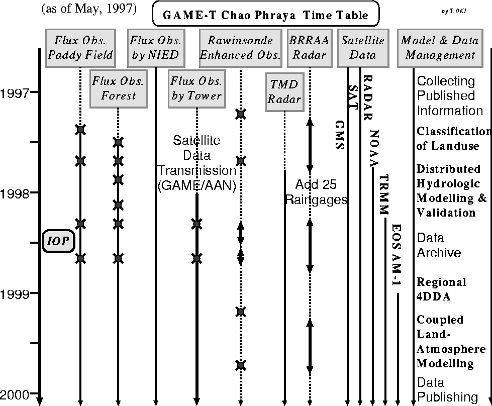
GAME-T Observations at a glance
A 32KB GIF image showing observation schedule by Prof. Oki
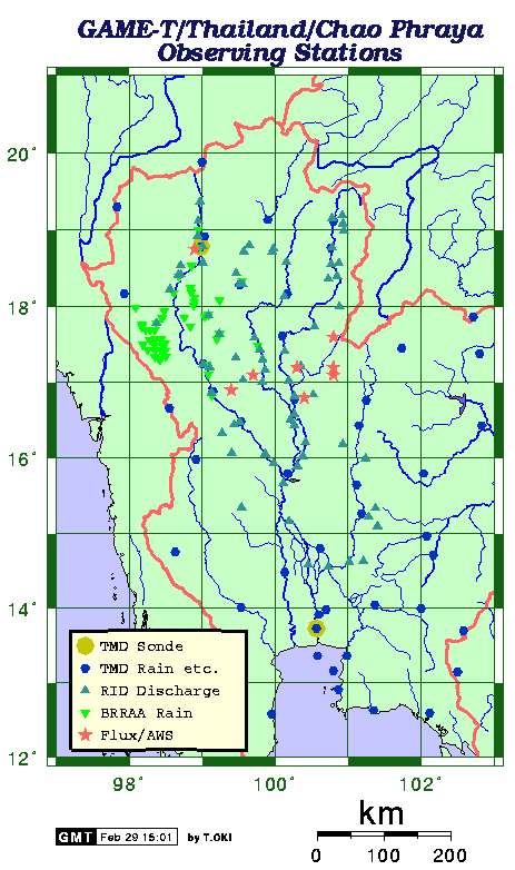
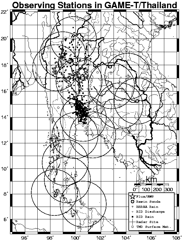
GAME-T/Thailand/Chao Phraya Observing Stations
A 24KB GIF image showing a map of observation stations made by Prof. Oki (See also new black-and-white version).
Summary of GAME-T Data Plan
From AMON(Asian Meteorology Online Newsletter), VOL. 1, NO. 4 (September 1997). Brief introduction of GAME-T data management strategy by Prof. Oki

Update Log

2004 Dec. 09
Error Correction: 3-hourly rainfall for 1997 was not correct. Fixed.
 
2004 Nov. 11
New Data : Daily / 3-hourly rainfall for 1997, 2001 and 2002
 

Images:
outside of GAME-T site=URL outside of this site | Data is protected by password=Data is protected (fully or partly) by password when accessed by on-line.

***** On-line resources at IIS, Univ. of Tokyo, Japan *****
GAME-T Data Center | GAME-T | Musiake and Oki Lab.(GAME-T headquarters), IIS, Univ. of Tokyo, Japanoutside of GAME-T site

***** On-line resources at NRCT, Bangkok, Thailand *****
GAME-T Data Center | GAME-T | NRCT Homepage outside of GAME-T site
This server was established in July 2002, on the courtesy of NRCT foreign affair division, and is being maintained by computer technology staffs in NRCT.


Dataset Manager : Dr. AGATA, Yasushi, Univ. of Tokyo, Japan (agata@iis.u-tokyo.ac.jp)

Date of Last Modification : Jun 4, 2008