FrontPage
General Information
Version Note: G3WBM
Current Version is G3WBM ver 1.3 (updated on 20 March, 2018).
Ver1.1: river-ocean boundary is improved.
Ver1.2: bug-fix around river mouths.
Ver1.3: bug-fix on grid coordination. Lisence changed to CC-BY 4.0
Version Note: G1WBM
Current Version is G1WBM ver 1.0 (updated on 20 March, 2018).
Ver1.0: 1sec version of G1WBM released
Abstract
Global 3 arc-second Water Body Map (G3WBM) is developed using an automated algorithm to process multi-temporal Landsat images from the Global Land Survey (GLS) database. We used 33,890 scenes from 4 GLS epochs in order to delineate a seamless water body map, without cloud and ice/snow gaps. Permanent water bodies were distinguished from temporal water-covered areas by calculating the frequency of water body existence from overlapping, multi-temporal, Landsat scenes. By analyzing the frequency of water body existence at 3 arc-second resolution, the G3WBM separates river channels and floodplains more clearly than previous studies.
In March 2018, the 1-second version is processed using the same method and data.
The PNG images of the G3WBM can be viewed without password.
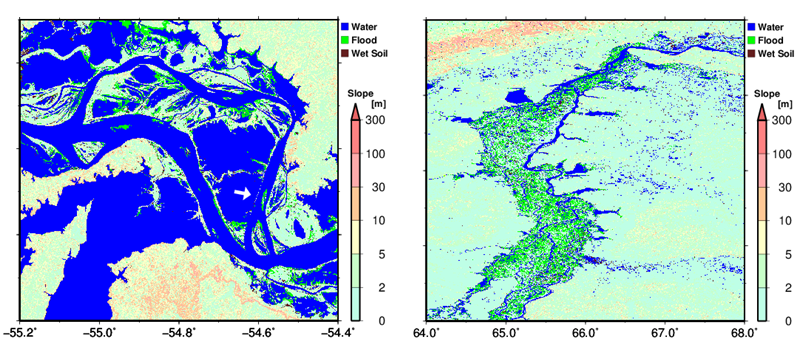
Zoom up image for the Amazon Floodplain and the Ob River
Description Paper / Reference
Please use the below journal paper to cite/refer the G3WBM database.
Citation to the paper is adequate if you simply use the dataset. If you asked help for additional handling/editing of the dataset, proper acknowledgement or co-authorship is recommended.
Dai Yamazaki, Mark Trigg, and Daiki Ikeshima
- Development of a global ~90 m water body map using multi-temporal Landsat images
- Remote Sensing of Environment
- Published online, 2015, DOI: 10.1016/j.rse.2015.10.014
- Click here to access the RSE Journal Page
Data Description
Data Format
The G3WBM/G1WBM is prepared as 5 degree x 5 degree tiles.
Filename represents the center of the lower left pixel of the data domain; e.g. the file "n30w120_wat.tif" is for the water body map of the domain N30-N35, W120-W115. More Precisely
for G3WBM: N29.999583333-N34.9995833, W120.0004167-W115.0004167
for G1WBM: N29.99986111-N34.99986111, W120.0001389-W115.0001389)
The 5 deg tiles are compressed into 30 degree (lat) by 30 degree (lon) package.
Package name represents the lower left corner of the package domain; e.g. the package "g1wbm_n30w120.tar" contains data files in the domain of N30-N60, W120-W090.
The data format is 'GeoTiff'.
Use of Data
License Agreement
The G3WBM/G1WBM is licensed under a Creative Commons Attribution 4.0 International License (CC-BY 4.0). To view a copy of this license, please visit http://creativecommons.org/licenses/by/4.0/. By downloading and using the data the user agrees to the terms and conditions of this license. Notwithstanding this free license, we ask users to refrain from redistributing the data in whole in its original format on other websites without the explicit written permission from the authors. G3WBM/G1WBM is available for download at http://hydro.iis.u-tokyo.ac.jp/~yamadai/G3WBM/. The copyright of G3WBM/G1WBM is held by the developers, 2018, all rights reserved.
Data sharing policy
Citation to the paper is adequate if you simply use the G3WBM/G1WBM. If you asked help for additional handling/editing of the dataset, or your research outcome highly depends on the product, the developer would request co-authorship.
Registration for Download
Please fill the Google Form to get an access to G3WBM/G1WBM
or please contact to the developer (yamadai [at] iis.u-tokyo.ac.jp) to get an access.
Download
G3WBM (password required)
0: Land
1: Land (No Landsat observation)
10: Snow
20: Wet Soil / Wet Vegetation / Lava
30: Salt Marsh
40: Temporal Flooded Area
50: Permanent Water
51: Permanent Water (Added by SWBD)
99: Ocean (Given by external land/sea mask)
N60-N90
g3wbm_n60w180.tar ::: g3wbm_n60e000.tar
g3wbm_n60w150.tar ::: g3wbm_n60e030.tar
g3wbm_n60w120.tar ::: g3wbm_n60e060.tar
g3wbm_n60w090.tar ::: g3wbm_n60e090.tar
g3wbm_n60w060.tar ::: g3wbm_n60e120.tar
g3wbm_n60w030.tar ::: g3wbm_n60e150.tar
N30-N60
g3wbm_n30w180.tar ::: g3wbm_n30e000.tar
g3wbm_n30w150.tar ::: g3wbm_n30e030.tar
g3wbm_n30w120.tar ::: g3wbm_n30e060.tar
g3wbm_n30w090.tar ::: g3wbm_n30e090.tar
g3wbm_n30w060.tar ::: g3wbm_n30e120.tar
g3wbm_n30w030.tar ::: g3wbm_n30e150.tar
N00-N30
g3wbm_n00w180.tar ::: g3wbm_n00e000.tar
n00w150 --no land data-- ::: g3wbm_n00e030.tar
g3wbm_n00w120.tar ::: g3wbm_n00e060.tar
g3wbm_n00w090.tar ::: g3wbm_n00e090.tar
g3wbm_n00w060.tar ::: g3wbm_n00e120.tar
g3wbm_n00w030.tar ::: g3wbm_n00e150.tar
S30-N00
g3wbm_s30w180.tar ::: g3wbm_s30e000.tar
g3wbm_s30w150.tar ::: g3wbm_s30e030.tar
g3wbm_s30w120.tar ::: g3wbm_s30e060.tar
g3wbm_s30w090.tar ::: g3wbm_s30e090.tar
g3wbm_s30w060.tar ::: g3wbm_s30e120.tar
g3wbm_s30w030.tar ::: g3wbm_s30e150.tar
S60-S30
g3wbm_s60w180.tar ::: g3wbm_s60e000.tar
s60w150 --no land data-- ::: g3wbm_s60e030.tar
s60w150 --no land data-- ::: g3wbm_s60e060.tar
g3wbm_s60w090.tar ::: g3wbm_s60e090.tar
g3wbm_s60w060.tar ::: g3wbm_s60e120.tar
g3wbm_s60w030.tar ::: g3wbm_s60e150.tar
G1WBM (password required)
0: Land
1: Land (No Landsat observation)
10: Snow
20: Wet Soil / Wet Vegetation / Lava
30: Salt Marsh
40: Temporal Flooded Area
50: Permanent Water
51: Permanent Water (Added by SWBD)
99: Ocean (Given by external land/sea mask)
N60-N90
g1wbm_n60w180.tar ::: g1wbm_n60e000.tar
g1wbm_n60w150.tar ::: g1wbm_n60e030.tar
g1wbm_n60w120.tar ::: g1wbm_n60e060.tar
g1wbm_n60w090.tar ::: g1wbm_n60e090.tar
g1wbm_n60w060.tar ::: g1wbm_n60e120.tar
g1wbm_n60w030.tar ::: g1wbm_n60e150.tar
N30-N60
g1wbm_n30w180.tar ::: g1wbm_n30e000.tar
g1wbm_n30w150.tar ::: g1wbm_n30e030.tar
g1wbm_n30w120.tar ::: g1wbm_n30e060.tar
g1wbm_n30w090.tar ::: g1wbm_n30e090.tar
g1wbm_n30w060.tar ::: g1wbm_n30e120.tar
g1wbm_n30w030.tar ::: g1wbm_n30e150.tar
N00-N30
g1wbm_n00w180.tar ::: g1wbm_n00e000.tar
n00w150 --no land data-- ::: g1wbm_n00e030.tar
g1wbm_n00w120.tar ::: g1wbm_n00e060.tar
g1wbm_n00w090.tar ::: g1wbm_n00e090.tar
g1wbm_n00w060.tar ::: g1wbm_n00e120.tar
g1wbm_n00w030.tar ::: g1wbm_n00e150.tar
S30-N00
g1wbm_s30w180.tar ::: g1wbm_s30e000.tar
g1wbm_s30w150.tar ::: g1wbm_s30e030.tar
g1wbm_s30w120.tar ::: g1wbm_s30e060.tar
g1wbm_s30w090.tar ::: g1wbm_s30e090.tar
g1wbm_s30w060.tar ::: g1wbm_s30e120.tar
g1wbm_s30w030.tar ::: g1wbm_s30e150.tar
S60-S30
g1wbm_s60w180.tar ::: g1wbm_s60e000.tar
s60w150 --no land data-- ::: g1wbm_s60e030.tar
s60w150 --no land data-- ::: g1wbm_s60e060.tar
g1wbm_s60w090.tar ::: g1wbm_s60e090.tar
g1wbm_s60w060.tar ::: g1wbm_s60e120.tar
g1wbm_s60w030.tar ::: g1wbm_s60e150.tar
PNG images (password not required)
BLUE: Permanent Water Body
RED: Permanent Water Body added by SWBD
GREEN: Temporal Flooded Area
BROWN: Wet Soil/Vegetation, Lava
OCHER: Salt Marsh
YELLOW: Snow/Ice
INDIGO: Ocean
Background: Topography (Slope)